home

[ Content | Sidebar ]

Pilestræde in Copenhagen – DK 🇩🇰

February 17th, 2013

International Volvo Photo Locations Part 57
Historic Volvo Photography Locations Overview

2008 - Volvo C30

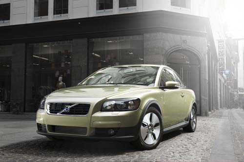
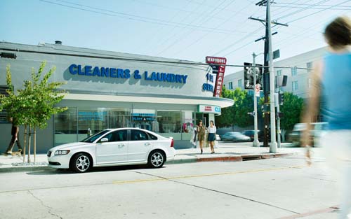
2008 – Volvo C30 Drive on Pilestræde in Copenhagen, Denmark 🇩🇰.

2008 - Volvo S40 Drive

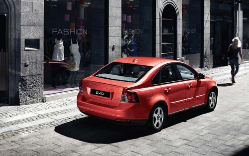
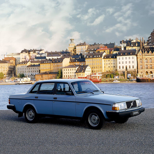
2008 – Volvo S40 Drive on Pilestræde in Copenhagen, Denmark 🇩🇰.

2008 - Volvo V50 Drive

2008 – Volvo V50 Drive on Pilestræde in Copenhagen, Denmark 🇩🇰.

2013 - Volvo S40 (Chinese version)

2013 – Volvo S40 (Chinese version) on Pilestræde in Copenhagen, Denmark 🇩🇰.

2013 - Pilestræde in København - DK

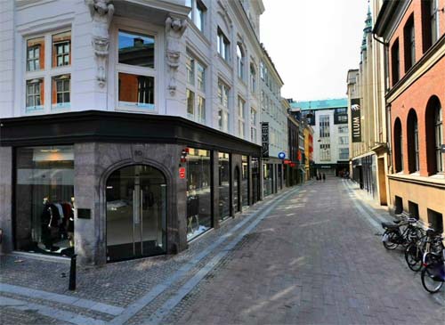
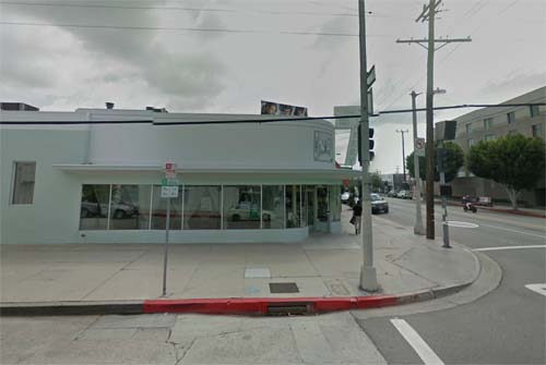
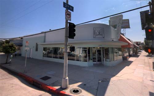
2013 – Pilestræde in København – DK (Krak.dk Gadefoto)

2008 - Making of...

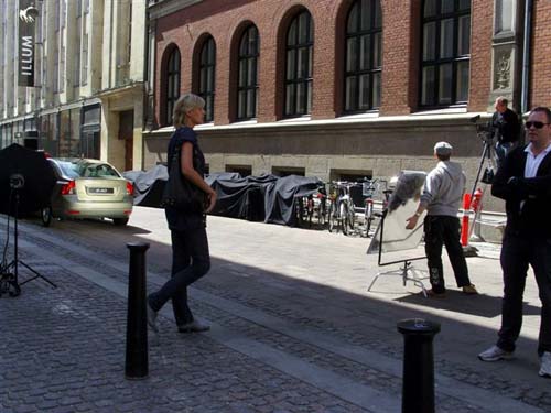
2008 – Making of… in Pilestræde in Copenhagen (davidfixare.se)

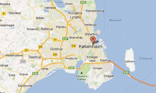
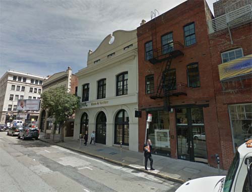
Pilestræde is a street in inner center district in Copenhagen, Denmark. The street extends over approx. 500 m from East Street to Landemærket, where it continues as Suhmsgade.

In 1970-1971 was Pilestræde straightened out to make room for the big expansion of Gutenberghuskomplekset by architect Preben Hansen, and in this connection which was cut several old buildings down. It was one of the last major demolitions in the City, as the municipality soon after the policy change, as it realized that big business expansion needs could not be met within the violent streets.

This Inner city district is the historic, geographic and political heart of present-day Copenhagen, and reflects the history of Denmark. Its boundaries pretty much reflect the entire city’s extent during the reign of King Christian IV (1588-1648).

The fashion shop in the picture is the HQ of Designers Remix, which was founded in 2002 by Charlotte Eskildsen with over 500 stores all across Europe, Russia, Asia and the Middle East. In 2012 Designers Remix was nominated and won the prestigious category “brand of the year” at Danish Fashion Award.

Pilestræde in København Map

More information at en.wikipedia.org and www.designersremix.com.

Historic Volvo Photography Locations Overview

Orlando Avenue in Los Angeles – USA 🇺🇸

February 17th, 2013

International Volvo Photo Locations Part 56
Historic Volvo Photography Locations Overview

2009 - Volvo S40

2009 – Volvo S40 at Magnolia Bakery on S Orlando Avenue and W 3rd Street in Beverly Grove in Los Angeles, USA 🇺🇸.

2013 - Orlando Avenue in Los Angeles - USA (Google Streetview)

2013 – Orlando Avenue in Los Angeles – USA (Google Streetview)

2013 - Orlando Ave in Los Angeles, USA (Bing Streetside)

2013 – Orlando Ave in Los Angeles, USA (Bing Streetside)

Orlando Avenue is located in Fairfax District in Los Angeles USA. The Fairfax Distric is roughly bordered by West Hollywood on the north, Highland Avenue on the east, West Hollywood and Beverly Hills on the west and Wilshire Boulevard on the south. The Fairfax District is sometimes confused with Park La Brea, which is a real estate development within the District, and the curious Beverly Hills Adjacent, particularly on housing rental advertisements. The section of Fairfax Avenue filled with traditionally Jewish businesses is sometimes referred to by Angelenos as Kosher Canyon or “The Bagel District.” Beginning around 2005, real estate listings controversially began to define the western part of the area as Beverly Grove when listing homes for sale.

Historically, the Fairfax District has been a center of the city’s Jewish community. In the early 20th century, with an expanding population and more young families, many began looking for new housing. As a result of this, many middle class Jewish families moved west from Boyle Heights, City Terrace, East Los Angeles and Montebello to the area around Fairfax Avenue, a street they lined with Kosher delis, restaurants, butcher’s and baker’s shops and fish markets, creating a unique village in the heart of the city.

In the late 1970s, after Governor Jerry Brown canceled the Beverly Hills Freeway, which would have razed the entire length of Melrose Avenue, that avenue became known as a street of funky shops, restaurants and galleries. The early 1980s brought media attention and a new revitalized look to the area. Today, Melrose Avenue remains a fashion district. It is perhaps similar to parts of SoHo and Greenwich Village in New York City, as well as the Haight-Ashbury and Upper Fillmore districts of San Francisco.

Photo of the Volvo S40 in front of the Cleaners & Laundry is taken at the corner of Orlando Avenue and West 3rd Street. Today, on this place, a Magnolia Bakery is located (8389 West 3rd Street (at the corner of Orlando) Los Angeles, CA 90048)

Orlando Avenue Los Angeles USA Map

More information at www.magnoliabakery.com and en.wikipedia.org.

Historic Volvo Photography Locations Overview

International Terminal Departures Level at San Francisco International Airport in San Francisco – USA 🇺🇸

February 17th, 2013

International Volvo Photo Locations Part 55
Historic Volvo Photography Locations Overview

2012 - Volvo S80

2012 – Volvo S80 on International Terminal Departures Level at San Francisco International Airport in San Francisco, California in USA 🇺🇸.

2013 - San Francisco International Airport in SF - USA (Bing Streetside)

2013 – San Francisco International Airport in SF – USA (Bing Streetside)

San Francisco International Airport (SFO) is a major international airport located 21 km south of downtown San Francisco, California, United States, near the cities of Millbrae and San Bruno in unincorporated San Mateo County. It is often referred to as SFO (from “San FranciscO”). The airport has flights to points throughout North America and is a major gateway to Europe and Asia.

SFIA 2 USA

It is the largest airport in the San Francisco Bay Area and the second busiest airport in California after Los Angeles International Airport. In 2009 San Francisco International Airport was the tenth busiest in the United States and the twentieth largest airport in the world, by passenger count.
It has the Louis A. Turpen Aviation Museum, the San Francisco Airport Commission Aviation Library, and permanent and temporary art exhibitions in several places in the terminals. Free Wi-Fi is available to the public in most of the terminal area.

SFIA USA

SFO’s international terminal was designed by Craig W. Hartman of Skidmore, Owings and Merrill and opened in December 2000 to replace International Departures from Terminal 2. It is the largest international terminal in North America, and is the largest building in the world built on base isolators to protect against earthquakes. Planners attempted to make the airport a destination in and of itself, not just for travelers that are passing through. The international terminal is a common use facility, with all gates and all ticketing areas shared among the international airlines. All international arrivals and departures are handled here (except flights from cities with customs preclearance). The BART train station is located in this terminal, at the garage leading to Boarding Area G. All the gates in this terminal have two jetway bridges with the exception of gates A2 and A10, which have one. Gates A1, A3, and A11 are capable of accommodating two aircraft.

For lack of space, the terminal was constructed on top of the airport’s main access road at enormous expense, completing the continuous “ring” of terminals. The terminal required its own elaborate set of ramps to connect it with Highway 101. The design and construction of the international terminal is owed to Skidmore, Owings & Merrill, Del Campo & Maru Architects, Michael Willis Associates (main terminal building), Hellmuth, Obata and Kassabaum (Boarding Area G), and Gerson/Overstreet Architects (Boarding Area A). The contracts were awarded after an architectural design competition. If all gates in an airlines’ designated international boarding area are full, passengers will board or deplane from the opposite international boarding area.

SFIA Maps

More information at www.flysfo.com and en.wikipedia.org.

Historic Volvo Photography Locations Overview

Carrer Antic de Sant Joan in Barcelona – ES 🇪🇸

February 10th, 2013

International Volvo Photo Locations Part 54
Historic Volvo Photography Locations Overview

2012 - Volvo XC60

2012 – Volvo XC60 on Carrer Antic de Sant Joan in Barcelona, Spain 🇪🇸.

2013 - Carrer Antic de Sant Joan in Barcelona, Spain (Google Streetview)

2013 – Carrer Antic de Sant Joan in Barcelona, Spain (Google Streetview)

Carrer Antic de Sant Joan is a street in the center of Barcelona, where some hip store are located. For example Casa Munich with its lustrous dark wooden floors and classic black-and-white striped wallpaper. And with a crystal chandelier on the ceiling, Casa Munich on Carrer Antic de Sant Joan doesn’t looks like a regular sport shoe store. But it is a fitting environment for the sneakers with the striking X logo that enjoy cult status in Spain. The colorful shoes are still made in a factory in Barcelona, as they have been since the company was founded in 1939.

Ciutat Vella, meaning in English “Old City”) is a district of Barcelona, numbered District 1. The name means “old city” in Catalan and refers to the oldest neighborhoods in the city of Barcelona, Spain. Ciutat Vella is nestled between the Mediterranean Sea and the neighborhood called l’Eixample (the Extension.). It is considered as the centre of the city; the Plaça Catalunya is one of the most popular meeting points in all of Catalonia.

Carrer Antic de Sant Joan Barcelona Map

More information on unlike.net and en.wikipedia.org

Historic Volvo Photography Locations Overview

C Street in San Diego – USA 🇺🇸

February 10th, 2013

International Volvo Photo Locations Part 53
Historic Volvo Photography Locations Overview

2010 - Volvo XC90

2010 – Volvo XC90 on C Street and 7th Avenue in San Diego, USA 🇺🇸.

2010 - C Street in San Diego in California USA

2010 – C Street and 7th Avenue in San Diego in California USA

2013 - C Street in San Diego in California USA (Google Streetview)

2013 – C Street in San Diego in California USA (Google Streetview)

San Diego is the eighth-largest city in the United States and second-largest city in California. The city is located on the coast of the Pacific Ocean in Southern California, immediately adjacent to the Mexican border. The birthplace of California, San Diego is known for its mild year-round climate, natural deep-water harbor, extensive beaches, long association with the U.S. Navy, and recent emergence as a healthcare and biotechnology development center.

Historically home to the Kumeyaay people, San Diego was the first site visited by Europeans on what is now the West Coast of the United States. Upon landing in San Diego Bay in 1542, Juan Cabrillo claimed the entire area for Spain, forming the basis for the settlement of Alta California 200 years later. The Presidio and Mission of San Diego, founded in 1769, were the first European settlement in what is now California.

San Diego’s main economic engines are military and defense-related activities, tourism, international trade, and manufacturing. The presence of the University of California, San Diego (UCSD), with the affiliated UCSD Medical Center, has helped make the area a center of research in biotechnology.

The San Diego Trolley is a light rail system operating in the metropolitan area of San Diego. It is known colloquially as The Trolley or by tourists as The Red Trolley. The Trolley began service on July 26, 1981,[1] and today operates three primary lines named the Blue Line, the Orange Line, and the Green Line, as well as a supplementary downtown circulator known as the Silver Line on weekends and holidays. With an average of 96,900 riders, the trolley is currently the 5th most-ridden light rail system in the United States.

Sub Marina on C Street and 6th Ave San Diego

Streets are laid out in a grid pattern and many are designated for one-way traffic. North/south roads have both names and numbers. The named roads begin with Harbor Blvd then move east past Pacific, Kettner, India, Columbia, State, Union and Front Street. The roads then numbered and are called Avenues, starting at 1st Avenue and contunuing to Park Blvd (12th Ave) The general pattern is that even numbered streets head south, and odd numbered streets go north. East/west streets are laid out alphabetically from A to K, with the exception of D,H & I which are replaced with Broadway, Market and Island streets respectively. Steets north of A Street are named after trees and start with Ash Street, and going up to Laurel.

C Street in San Diego CA USA Map

More information at www.sandiego.org and en.wikipedia.org.

Historic Volvo Photography Locations Overview

North East 39 Street in Miami – USA 🇺🇸

February 10th, 2013

International Volvo Photo Locations Part 52
Historic Volvo Photography Locations Overview

2009 - Volvo S80

2009 – Volvo S80 at North East 39 Street in Miami, USA 🇺🇸.

2013 - North East 39 Street in Miami Florida in USA (Google Streetview)

2013 – North East 39 Street in Miami Florida in USA (Google Streetview)

NE 39 Street is a street in the Design District in Miami Florida, USA. The photo is made where Northe East 39 Street meets Northe East 2 Avenue.

The Design District, historically a part of the Buena Vista, is a neighborhood of greater Midtown, Miami, Florida, United States, south of Little Haiti. It is roughly bound by North 36 St (US 27) to the south, North 43rd Street to the north, West First Avenue to the west and Biscayne Boulevard to the east.

The Design District is made up primarily of old low-rise warehouses and gallery spaces, that have been reconverted into retail spaces, art galleries, restaurants and cafés. The Design District is in the crossroads of many prominent Miami neighborhoods, with the artsy Wynwood neighborhood to the south, Little Haiti and the historic 1920s Buena Vista neighborhood to the north, and the wealthy Upper East Side neighborhoods to the east. After decades of falling to urban decay, the Design District has risen to fame as a destination for the arts, design, and fashion.

It is home to over 130 art galleries, showrooms, creative services, architecture firms, stores, antiques dealers, eateries and bars.[2] Every 2nd Saturday of each month a community wide Art & Design Night is held from 7-10 pm. A popular event, Art Galleries and Design Showrooms open their doors to the public for music and refreshments.

Miami is a city located on the Atlantic coast in southeastern Florida and the county seat of Miami-Dade County. The 42nd largest city proper in the United States, with a population of 408,568, it is the principal, central, and most populous city of the Miami metropolitan area, and the most populous metropolis in the Southeastern United States.

NE 39 ST in Miami - USA

More information at www.miamidesigndistrict.net and en.wikipedia.org.

Historic Volvo Photography Locations Overview

Keker, Van Nest & Peters LLP on Sansome Street in San Francisco – USA 🇺🇸

February 10th, 2013

International Volvo Photo Locations Part 51
Historic Volvo Photography Locations Overview

2009 - Volvo XC60

2009 – Volvo XC60 at Keker, Van Nest & Peters LLP on Sansome Street in San Francisco – USA 🇺🇸

2013 - Sansome Street in San Francisco USA (Google Streetview)

2013 – Sansome Street in San Francisco USA (Google Streetview)

Sansome street is a street in the financial center of San Francisco in California, USA.

At the begining of Sansome Street, there is the famous One Sansome Street building, also known as Citigroup Center. It is an office skyscraper located at the intersection of Sutter and Sansome Streets in the Financial District of San Francisco, California near Market Street. The 168 m, 41 floor, 54,578.0 m2 office tower was completed in 1984.

The One Sansome Street tower is built adjacent to the site of the ornate Anglo and London Paris National Bank, which was completed in 1910. Designed by architect Albert Pissis, the bank building was granite clad with 12 m high Doric columns. The historic architecture of the bank building serves as a conservatory for the skyscraper today.

Keker & Van Nest LLP is a premier litigation boutique located in San Francisco, California. For more than thirty years, Keker & Van Nest has tried and litigated complex, high-stakes civil and criminal cases throughout the nation. Areas of practice include intellectual property, professional liability, class actions, general contract and commercial litigation, antitrust, white collar crime, and appellate.

The Financial District is a neighborhood in San Francisco, California, that serves as its main central business district. It is home to the city’s largest concentration of corporate headquarters, law firms, insurance companies, real estate firms, banks, savings and loans, and other financial institutions.
The area is marked by the cluster of high-rise towers in the triangular area east of Grant Avenue, south of Washington Street, west of the Embarcadero that rings the waterfront, and north of Market Street. The city’s tallest buildings, including 555 California Street and the Transamerica Pyramid, and many other tall buildings, such as 101 California Street and 345 California Street are located there. Montgomery Street (“Wall Street of the West”) is the traditional heart of the district.

Sansome Street in San Francisco Map

More information at en.wikipedia.org, www.kvn.com and www.inetours.com.

Historic Volvo Photography Locations Overview

Södra Riddarholmshamnen in Stockholm 🇸🇪

February 9th, 2013

Volvo Photo Locations Part 119
Historic Volvo Photography Locations Overview

1983 – Volvo 240 Diesel on Södra Riddarholmshamnen with view on Söder Mälarstrand in Stockholm

1983 - Volvo 240 Diesel

1983 – Volvo 240 Diesel on Södra Riddarholmshamnen with view on Söder Mälarstrand in Stockholm

1983 – Volvo 240 Diesel on Södra Riddarholmshamnen with view on Söder Mälarstrand in Stockholm

1983 - Volvo 240 Diesel

1983 – Volvo 240 Diesel on Södra Riddarholmshamnen with view on Söder Mälarstrand in Stockholm

2013 - Söder Mälarstrand in Stockholm (Eniro Gatuvy)

2013 – Södra Riddarholmshamnen with view on Söder Mälarstrand in Stockholm (Eniro Gatuvy)

2013 - Söder Mälarstrand in Stockholm (Hitta Gatubild)

2013 – Södra Riddarholmshamnen with view on Söder Mälarstrand in Stockholm (Hitta Gatubild)

2013 - Söder Mälarstrand in Stockholm (Google Maps)

2013 – Södra Riddarholmshamnen with view on Söder Mälarstrand in Stockholm (Google Maps)

2013 - Den Röda Båten Mälaren on Söder Mälarstrand in Stockholm

2013 – Den Röda Båten Mälaren on Söder Mälarstrand in Stockholm

Söder Mälarstrand is a road with quay on Södermalm in Stockholm. It stretches along the Riddarfjärden from Pålsundet in the west to Centralbron in the east.
Along the street there are some interesting places like Heleneborg, Münchenbryggeriet and Mariahissen.

Photo’s shown above are all taken from Birger Jarls Torg on Riddarholmen. From there you have a wonderfull view on the Södra Riddarholmshamnen.

2013 - View from Söder Mälarstrand to Riddarholmen

2013 – View from Söder Mälarstrand to Riddarholmen

Söder Mälarstrand Map

More information at www.theredboat.com and www.visitstockholm.com.

Historic Volvo Photography Locations Overview

Hôtel de Paris on Avenue de Monte-Carlo in Monaco – MC

February 7th, 2013

International Volvo Photo Locations Part 50
Historic Volvo Photography Locations Overview

1992 - Volvo 460 GLE

1992 – Volvo 460 GLE at Hôtel de Paris on Avenue de Monte-Carlo in Monaco

1992 - Volvo 460 GLE

1992 – Volvo 460 GLE at Hôtel de Paris on Avenue de Monte-Carlo in Monaco

1998 – Volvo C70 at Hôtel de Paris on Avenue de Monte-Carlo in Monaco

2013 - Hotel de Paris on Avenue de Monte-Carlo in Monaco (Google Streetview)

2013 – Hôtel de Paris on Avenue de Monte-Carlo in Monaco (Google Streetview)

The Hôtel de Paris Monte-Carlo is a hotel located in Monte Carlo, Monaco, It was opened in 1863 as part of the development of Monte Carlo by the Société des Bains de Mer (SBM) under the auspices of Charles III of Monaco.

The Hôtel de Paris Monte-Carlo is a luxury hotel at the heart of Monte Carlo and is owned and operated by SBM, along with the Hôtel Hermitage Monte-Carlo, the Monte-Carlo Beach Hotel and the Monte-Carlo Bay Hotel & Resort. The hotel is regularly listed on the annual Conde Nast Traveller Gold List. It has notable restaurants, including the Michelin 3-star Louis XV and Michelin-starred Le Grill, as well as the Le Bar Americain.

Hotal de Paris Avenue de Monte-Carlo Night

The hotel was featured in the 1948 Michael Powell-Emeric Pressburger film The Red Shoes as the place where the stars of the Ballet Lermontov stayed.
The hotel was featured in the 2010 American film Iron Man 2, during the Monaco Grand Prix.
The hotel was featured in the 2011 film Monte Carlo, starring Selena Gomez, as the place where the group stayed in Monte Carlo.
The hotel was seen in two James Bond films, Never Say Never Again (an un-official film) and GoldenEye (official Eon production)
The Diamond Suite Charles Garnier of the hotel was featured in the 2012 animated film, Madagascar 3: Europe’s Most Wanted. The suite was Skipper’s retreat as part of his honeymoon to Monte Carlo.

Formula One and Hotel de Paris Monaco

Monaco’s Formula 1 Grand Prix needs no introduction! Every year, for four days in May, the eyes of the entire world are focused on this town which is transformed into a race track, a track that transforms the town.

Hotal de Paris Avenue de Monte-Carlo Map

More information on www.hoteldeparismontecarlo.com

Historic Volvo Photography Locations Overview

La Salle Street Bridge in Chicago – USA 🇺🇸

February 7th, 2013

International Volvo Photo Locations Part 49
Historic Volvo Photography Locations Overview

2010 – Volvo C30 on La Salle Street Bridge in Chicago USA 🇺🇸

2012 - Volvo C30

2010 – Volvo C30 on La Salle Street Bridge in Chicago, USA 🇺🇸 (photography by Nigel Harniman)

2013 - North La Salle Drive in Chicago USA (Google Streetview)

2013 – La Salle Street Bridge and North La Salle Drive in Chicago USA (Google Streetview)

The La Salle Street Bridge (or Marshall Suloway Bridge) is a single-deck double-leaf trunnion bascule bridge spanning the main stem of the Chicago River in Chicago, Illinois, that connects the Near North Side with the Loop area. It was constructed in 1928 at a cost of $2,500,000 by the Strobel Steel Constructing Company.

The bridge was part of a scheme to widen LaSalle Street and improve access from the Loop to the north side of the river that had been proposed as early as 1902. The design of the bridge, along with those for new bridges at Madison, Franklin, and Clark streets, was approved in 1916.

La Salle Street Bridgekopie

LaSalle Street is a major north-south street in Chicago named for Sieur de La Salle, an early explorer of Illinois. The portion that runs through the Chicago Loop is considered to be Chicago’s financial district.

Moving north from the Loop, the street crosses the Chicago River using the La Salle Street Bridge. North of the river, the city’s signage refers to, “LaSalle Boulevard,” between the river and North Avenue. Between North Avenue (where it picks up Illinois Route 64 until its north end) and Lake Shore Drive, the signage refers to, “LaSalle Drive.”

The street, Chicago Board of Trade Building, and 200 North LaSalle were used in the 2005 film Batman Begins and its sequel The Dark Knight. The view facing south down the canyon has been used in the movies The Untouchables, Public Enemies, Transformers: Dark of the Moon and Road to Perdition. The canyon was in the movie Ferris Bueller’s Day Off.

The photo with the Volvo C30 driving on the La Salla Street Bridge was modified on the computer. The crew shoot a backplate in Chicago and the Volvo C30 was later added later in the studio in England. The used backplate from Chicago was turned 180 degrees (as you can see in the original streetview photo).

N LaSalle St, Chicago Map

More information at en.wikipedia.org and www.harniman.com.

Historic Volvo Photography Locations Overview