home

[ Content | Sidebar ]

2014 Volvo S60 & XC60

February 23rd, 2013

This week Volvo Cars launched their 2014 models of the S60, V60, XC60, V70, XC70 and S80 in Volvohallen in Torslanda, Göteborg.

Responsible for the exterior redesign of the S60 was Peter Reuterberg, senior exterior designer at Volvo Cars.

”Det är precis som på en människa, det första man ser är ögonen” quote from Peter Reuterberg.

2014 Volvo S60 design study sketch by Peter Reuterberg

2014 Volvo S60 design study sketch by Peter Reuterberg

2014 Volvo S60 design study sketch by Peter Reuterberg

2014 Volvo S60 design study sketch by Peter Reuterberg

2014 Volvo S60 design study sketch by Peter Reuterberg

2014 Volvo S60 design study sketch by Peter Reuterberg

2014 Volvo S60 design study sketch by Peter Reuterberg

2014 Volvo S60 design study sketch by Peter Reuterberg

2014 Volvo S60 design study sketch by Peter Reuterberg

2014 Volvo S60 design study sketch by Peter Reuterberg

2014 Volvo S60 design study sketch by Peter Reuterberg

2014 Volvo S60 design study sketch by Peter Reuterberg

Responsible for the exterior redesign of the XC60 was Steve Potter, senior designer at Volvo Cars, who already was resposible for the exterior design of the original XC60 under Steve Mattin.

2014 Volvo XC60 design study sketch by Steve Potter

2014 Volvo XC60 design study sketch by Steve Potter

2014 Volvo XC60 design study sketch by Steve Potter

2014 Volvo XC60 design study sketch by Steve Potter

Have a look at the video of the launch with short presentation of some of the responsble designers.

Karl Marx Allee near Strausberger Platz in Berlin – D 🇩🇪

February 19th, 2013

International Volvo Photo Locations Part 66
Historic Volvo Photography Locations Overview

2014 - Volvo V70

2014 – Volvo V70 on Karl Marx Allee near Strausberger Platz in Berlin, Germany 🇩🇪.

2013 - Karl Marx Allee towards Strausberger Platz in Berlin Germany (Google Streetview)

2013 – Karl Marx Allee towards Strausberger Platz in Berlin Germany (Google Streetview)

The Strausbergerplatz is a large urban square in the Berlin district of Friedrichshain and marks the border to Mitte. It is connected to the Karl-Marx-Allee to Alexanderplatz and the Lichtenberger street with the square of the United Nations. These two roads intersect at an oval roundabout at Strausbergerplatz.

The houses on Strausbergerplatz are like in the rest of Karl-Marx-Allee complex design and predominantly own eight floors. The ground floor of the houses being built as a loading zone. The four outputs are designed torartig. North and south of the road Lichtenberger this is achieved in that the stressed corner houses nearly come close to the road and the footpath passes through it. The gatehouse at the east and west side stand next to their special design distinguished by its height. The eastern end of the course consists of two 10-storey buildings, and the western entrance are two 14-storey high-rise buildings. These were called “House of the Child” and “Berlin House” built and were in contrast to the other buildings of the Stalin Allee in the 1950s, built as prefabricated buildings of reinforced concrete components.

2013 - Strausberger Platz in Berlin

2013 – Strausberger Platz in Berlin

The Fernsehturm (English: television tower) is a television tower in the city centre of Berlin, Germany. Close to Alexanderplatz, the tower was constructed between 1965 and 1969 by the former German Democratic Republic administration who intended it as a symbol of Berlin, which it remains today,[1] as it is easily visible throughout the central and some suburban districts of Berlin. With its height of 368 meters, it is the tallest structure in Germany.

1970 - Strausberger Platz in Berlin

1970 – Strausberger Platz in Berlin

The original total height of the tower was 365 metres, but it rose to 368 metres after the installation of a new antenna in the 1990s. The Fernsehturm is the fourth tallest freestanding structure in Europe, after Moscow’s Ostankino Tower, the Kiev TV Tower and the Riga Radio and TV Tower. There is a visitor platform and a revolving restaurant in the middle of the sphere. The visitor platform, also called panoramic floor, is at a height of about 203 metres above the ground and visibility can reach 42 kilometres on a clear day. The restaurant Telecafé, which rotates once every 30 minutes, is a few metres above the visitors platform at 207 metres (originally it turned once per hour; the speed was later doubled following the tower’s late 1990s renovation). Inside the shaft are two lifts that shuttle visitors up to the sphere of the tower within 40 seconds. It is not accessible by wheelchair. There is also a Staircase with 986 steps.

Karl Marx Allee in Berlin D Map

More information on en.wikipedia.org and de.wikipedia.org.

Historic Volvo Photography Locations Overview

An der Alster 1 in Hamburg – D 🇩🇪

February 19th, 2013

International Volvo Photo Locations Part 65
Historic Volvo Photography Locations Overview

2014 - Volvo V60 Plug-in Hybrid

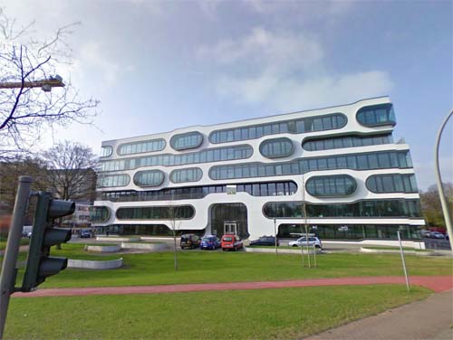
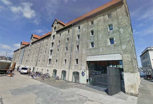
2014 – Volvo V60 Plug-in Hybrid at An der Alster 1 in Hamburg, Germany 🇩🇪.

2013 - An der Alster 1 in Hamburg, Germany (Google Streetview)

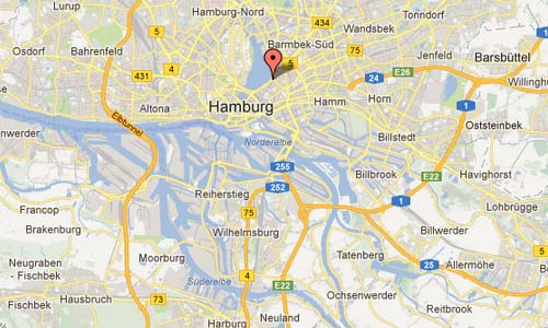
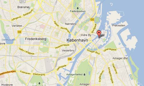
2013 – An der Alster 1 in Hamburg, Germany (Google Streetview)

An der Alster 1 is a office complex in Hamburg, Germany, designed by J. Mayer H Architects and completed in 2007. It can be found at the corener of An der Alster and Sechslingspforte in Hamburg, Germany.

The building site is situated at the intersection between the Hamburg’s lively downtown and its urban landscape rich in water and mature trees. It is at the transition from city to nature, and the gateway building to the bustling metropolitan core. The horizontal striped facade with its floating ‘eyes’ celebrates the view onto this unique context.

A public park in front of the building continues the design strategy of the facade into the landscape. The ‘eyes’ in the façade and the platforms in the park form places to meet and contemplate.

The office spaces serve both a generic spatial layout and specific moments related to the ‘eyes’. Large spans provide for various office layout configurations in combination with balconies and climatically tempered outdoor spaces of the ‘eyes’.

The office building An der Alster 1 links interior and exterior spaces to the public park in front of the building and to the city context of Hamburg, becoming a new anchor at the prestigious Aussenalster waterfront.

2013 - An der Alster 1 in Hamburg, Germany (Hiepler Brunier)

2013 – An der Alster 1 in Hamburg, Germany (Hiepler Brunier)

The Alster is a right tributary of the River Elbe in Northern Germany. It has its source near Henstedt-Ulzburg, Schleswig-Holstein, flows roughly southwards and reaches the Elbe in Hamburg. In the centre of Hamburg the Alster has been dammed. The Alster forms two artificial lakes in the city of Hamburg.

Hamburg was founded at the mouth of the Alster river in the 9th century and used it as a port. The water was used to flood the moats of the fortifications. The Alster has been dammed since 1190, originally to power a watermill. In 1235 a further dam was built for a second mill, which changed the shape of the river to be like a lake.

In the 15th and 16th century, an Alster canal was built to connect Hamburg with Lübeck. The canal was about 8 km long and built from the Alster to the Beste, a tributary of the Trave river, at Sülfeld. Because of the difficulties in holding water, especially near marsh areas, the 91 km long waterway from Hamburg to Lübeck was navigable from 1529 to 1550 only.

The city of Hamburg expanded along the shores of the Alster river, and several locks were constructed to make the river navigable. Until the 19th century water transport with barges were used up to the town of Kayhude. The barges—transporting building material, fuel, and foods—were staked or hauled.

An der Alster in Hamburg D Map

More information on www.dezeen.com and www.jmayerh.de.

Historic Volvo Photography Locations Overview

Little Italy on Green Street in San Francisco – USA 🇺🇸

February 17th, 2013

International Volvo Photo Locations Part 64
Historic Volvo Photography Locations Overview

2008 - Volvo S40

2008 – Volvo S40 on Green Street in San Francisco, USA 🇺🇸.

2013 - Green Street in Little Italy in San Francisco, USA (Google Streetview)

2013 – Green Street in Little Italy in San Francisco, USA (Google Streetview)

Green Street is a street in Little Italy in the North Beach area in San Francisco, USA.

Italian immigrants took San Francisco by storm in the early 20th century, establishing the most picturesque Little Italy in the United States: North Beach. Although North Beach still absolutely teems with Italian eateries-some of them world famous for their authenticity or creativity-it is also studded with low quality tourist traps, designed to lure those out of the loop in for overpriced mediocrity. In fact, many of San Francisco’s best Italian restaurants are actually hidden away in more residential neighborhoods, where hyper-critical locals keep quality standards at their highest.

Often sporting a line out the door, Sodini’s is an old school San Francisco Italian restaurant that has been a favorite among locals and tourists alike for decades. The window reads “No Reservations, No Decaf, No Desserts, No Exceptions” and it is this kind of no-nonsense attitude, which focuses on the food instead of the pleasantries, that has kept Sodini’s from being corrupted by fame like many of its North Beach neighbors. Sodini´s is pictured above and located at 510 Green Street.

North Beach is a neighborhood in the northeast of San Francisco adjacent to Chinatown, Fisherman’s Wharf and Russian Hill. The neighborhood is San Francisco’s Little Italy, and has historically been home to a large Italian American population. It is still home to many Italian restaurants today, though many other ethnic groups currently live in the neighborhood. It was also the historic center of the beatnik subculture.
Today, North Beach is one of San Francisco’s main red light and nightlife districts as well as a residential neighborhood populated by a mix of young urban professionals, families and Chinese immigrants connected to the adjacent Chinatown.

The American Planning Association (APA) has named North Beach as one of ten ‘Great Neighborhoods in America’.

Green Street Little Italy SF Map

More information at en.wikipedia.org.

Historic Volvo Photography Locations Overview

Grant Avenue in San Francisco – USA 🇺🇸

February 17th, 2013

International Volvo Photo Locations Part 63
Historic Volvo Photography Locations Overview

2008 - Volvo S40

2008 – Volvo S40 on Grant Avenue in San Francisco, USA 🇺🇸.

2013 - Grant Avenue in Chinatown, San Francisco, USA (Google Streetview)

2013 – Grant Avenue in Chinatown, San Francisco, USA (Google Streetview)

Grant Avenue is one of the oldest streets in Chinatown. Originally, it was named Calle de la Fundacion (street of the founding) in 1845 in the pueblo of Yerba Buena. When California was ceded to the Union in 1846, the street was renamed Dupont Street, honoring an admiral from the USS Portsmouth. By the late 1800s, the street had gained an unsavory reputation being part of the Barbary Coast Trail along with Tong wars, sing-sing girls, and opium dens. After the 1906 earthquake, Dupont Street was upgraded and its image changed. It was changed to Grant Avenue to honor President Ulysses S. Grant, the 18th president of the United States. Some older members of the Chinese community still call it “Du Pon Gai”. Gai means “street” in Chinese.

Today, Grant Avenue at Bush Street houses the southern gateway to Chinatown. Stepping through the gateway is like walking into a whole new world. The street is lined with dragon-entwined lamp posts and calligraphy street signs. Shops filled with food, herbs, porcelains, furniture, fabrics, and trinkets from China, Hong Kong, and Taiwan. The architecture along Grant Avenue varies widely from Old St. Mary’s to the Sing Chong Building. Chinatown officially ends at Broadway Street.

Chinatown SF USA

More information at www.sanfranciscochinatown.com and en.wikipedia.org.

Historic Volvo Photography Locations Overview

Dumaine Street in New Orleans – USA 🇺🇸

February 17th, 2013

International Volvo Photo Locations Part 62
Historic Volvo Photography Locations Overview

2006 - Volvo C70

2006 – Volvo C70 on Dumaine Street in New Orleans, USA 🇺🇸.

2006 - Volvo C70

2006 – Volvo C70 on Dumaine Street in New Orleans, USA 🇺🇸.

2013 - Dumaine Street in New Orleans, USA (Google Streetview)

2013 – Dumaine Street in New Orleans, USA (Google Streetview)

New Orleans (French: La Nouvelle-Orléans) is a major United States port and the largest city and metropolitan area in the state of Louisiana. The city is named after Orléans, a city located on the Loire River in Centre, France, and is well known for its distinct French Creole architecture, as well as its cross-cultural and multilingual heritage. New Orleans is also famous for its cuisine, music (particularly as the birthplace of jazz), and its annual celebrations and festivals, most notably Mardi Gras. The city is often referred to as the “most unique” in America.

New Orleans is located in southeastern Louisiana, straddling the Mississippi River. The city and Orleans Parish (French: paroisse d’Orléans) are coterminous. The city and parish are bounded by the parishes of St. Tammany to the north, St. Bernard to the east, Plaquemines to the south and Jefferson to the south and west. Lake Pontchartrain, part of which is included in the city limits, lies to the north and Lake Borgne lies to the east.

New Orleans has many major attractions, from the world-renowned French Quarter and Bourbon Street’s notorious nightlife to St. Charles Avenue (home of Tulane and Loyola Universities, the historic Pontchartrain Hotel, and many 19th century mansions), to Magazine Street, with its many boutique stores and antique shops.

The French Quarter (known locally as “the Quarter” or Vieux Carré), which dates from the French and Spanish eras and is bounded by the Mississippi River, Rampart Street, Canal Street, and Esplanade Avenue, contains many popular hotels, bars, and nightclubs. Notable tourist attractions in the Quarter include Bourbon Street, Jackson Square, St. Louis Cathedral, the French Market (including Café du Monde, famous for café au lait and beignets) and Preservation Hall. To tour the port, one can ride the Natchez, an authentic steamboat with a calliope, which cruises the Mississippi the length of the city twice daily. Unlike most other places in The United States, and the world, New Orleans has become widely known for its element of elegant decay. The city’s many beautiful cemeteries and their distinct above-ground tombs are often attractions in themselves, the oldest and most famous of which, Saint Louis Cemetery, greatly resembles Père Lachaise Cemetery in Paris.

Dumaine Street in New Orleans Louisiana USA Map

More information at en.wikipedia.org and www.neworleansonline.com.

Historic Volvo Photography Locations Overview

Biltmore Hotel LA on South Grand Avenue in Los Angeles – USA 🇺🇸

February 17th, 2013

International Volvo Photo Locations Part 61
Historic Volvo Photography Locations Overview

2011 - Volvo S60

2011 – Volvo S60 at Biltmore Hotel LA on South Grand Avenue in Los Angeles in USA 🇺🇸.

2013 - Biltmore Hotel LA on South Grand Avenue in Los Angeles in USA (Google Streetview)

2013 – Biltmore Hotel LA on South Grand Avenue in Los Angeles in USA (Google Streetview)

The South Grand Avenue is a street in Downtown Los Angeles, USA. It is located in the Bunker Hill district. Bunker Hill is the cultural heart of Los Angeles, with several arts schools, theaters and performance venues along Grand Avenue. Guided tours of the neighborhood are provided by the Los Angeles Conservancy for a small fee. The neighborhood is accessible via the Metro Red/Purple Line Civic Center Station.

Many of the older buildings and the early high-rises surrounding Bunker Hill are undergoing adaptive reuse from commercial to residential. This trend began in 2000, when the Los Angeles City Council passed an Adaptive Re-Use Ordinance, allowing old unused office buildings to be redeveloped as apartments or “lofts.” Developers realized there was a high level of pent-up demand for living in or near downtown, by both artists and employees of various firms in the financial district and government workers in the Civic Center, and that they could profit by supplying housing to meet such demand.

Because of the popularity of the New Urbanism in California, the city has required developers to build mixed-use residential buildings as much as possible. This means that the first floor of such residential developments are devoted to commercial retailers, so that residents do not have to constantly drive around for all their shopping trips and buildings present a more welcoming facade to passersby on the sidewalk.

The Millennium Biltmore Hotel has been the premier choice for celebrities, presidents and dignitaries for nearly 90 years. Few Los Angeles hotels boast the ideal locale and sumptuous comforts this luxury hotel has to offer. Situated at the heart of L.A’s vibrant cultural district, the hotel is just steps away from major attractions, such as L.A. Live, the Ahmanson Theatre, Walt Disney Concert Hall and Dodger Stadium.

South Grand Ave in LA USA Map

More information at www.millenniumhotels.com and en.wikipedia.org.

Historic Volvo Photography Locations Overview

Santa Fe Avenue in Los Angeles – USA 🇺🇸

February 17th, 2013

International Volvo Photo Locations Part 60
Historic Volvo Photography Locations Overview

2010 – Volvo S60 on Santa Fe Avenue in Los Angeles, USA 🇺🇸.

2011 - Volvo S60

2010 – Volvo S60 on Santa Fe Avenue in Los Angeles, USA 🇺🇸.

2010 - Volvo S60

2010 – Volvo S60 on Santa Fe Avenue in Los Angeles, USA 🇺🇸.

2013 - Santa Fe Avenue (near East 6st Street) in Los Angeles USA (Google Streetview)

2013 – Santa Fe Avenue (near East 6st Street) in Los Angeles USA (Google Streetview)

Santa Fe Avenue (near East 6st Street) is a street in the Skid Row area in Los Angeles USA.

Skid Row, officially known as Central City East, is an area of Downtown Los Angeles. As of the 2000 census, the population of the district was 17,740. While no defined boundaries exist, Skid Row is generally used to refer to the area east of San Pedro Street, south of Third Street, west of Central Avenue, and north of Seventh Street.

The area contains one of the largest stable populations of homeless persons in the United States. Local homeless count estimates have ranged from 3,668 to 5,131. People passing through this area see cardboard boxes and camping tents lining the sidewalks.

The name is official enough that fire engines and ambulances serving the neighborhood have historically had “Skid Row” emblazoned on their sides. On June 1, 2006, the Los Angeles Times reported that fire officials planned to change the legend on the vehicles to read “Central City East”. Many residents supported the change, but it was opposed by firefighters and some residents who take pride in the sense that they live in a tough area.

The Los Angeles Downtown Industrial District (LADID) is a business improvement district that covers 44 blocks with boundaries roughly between Third (N) and Eighth and Olympic (S), San Pedro (W) and Alameda (E) Streets. LADID is administered by the Central City East Association (CCEA), the principal advocate for property owners, businesses, employees and residents in the eastern half of Downtown Los Angeles.

Safe & Clean services for LADID. Maintenance services include sweeping, steam cleaning and related surface maintenance control issues. Maintenance crews provide services 6 days a week. Including trash removal, graffiti removal, sidewalk cleaning/weed abatement and abandoned property removal. The public safety program includes crime prevention (assists in the prevention of break-ins, automobile-related crimes and generally disruptive street elements), and crime suppressionsuppression.

Santa Fe Ave in LA Map

More information on en.wikipedia.org and www.centralcityeast.org.

Historic Volvo Photography Locations Overview

Kobetabidea Bidea in Bilbao – ES 🇪🇸

February 17th, 2013

International Volvo Photo Locations Part 59
Historic Volvo Photography Locations Overview

2012 - Volvo V40

2012 – Volvo V40 at Kobetabidea Bidea in Bilbao, Spain 🇪🇸.

2012 – Volvo V40 at Kobetabidea Bidea in Bilbao, Spain 🇪🇸.

2012 – Volvo V40 at Kobetabidea Bidea in Bilbao, Spain 🇪🇸.

2012 - Volvo V40

2012 – Volvo V40 at Kobetabidea Bidea in Bilbao, Spain 🇪🇸.

2012 – Volvo V40 at Kobetabidea Bidea in Bilbao, Spain 🇪🇸.

2013 - View on Bilbao from Kobetabidea Bidea in Bilbao - Spain (Google Streetview)

2013 – View on Bilbao from Kobetabidea Bidea in Bilbao – Spain (Google Streetview)

Bilbao is a municipality and city in Spain, the capital of the province of Biscay in the autonomous community of the Basque Country. With a population of 353,187 as of 2010, it is the largest city of its autonomous community and the tenth largest in Spain. With roughly 1 million inhabitants, Bilbao lies within one of the most populous metropolitan areas in northern Spain.

The Bilbao metropolitan area includes the comarca of Greater Bilbao plus satellite towns, ranking the fifth largest in Spain.
Bilbao is situated in the north-central part of Spain, some 14 kilometres south of the Bay of Biscay, where the estuary of Bilbao is formed. Its main urban core is surrounded by two small mountain ranges with an average elevation of 400 metres.

Since its foundation in the early 14th century by Diego López V de Haro, head of the powerful Haro family, Bilbao was a commercial hub that enjoyed significant importance in the Green Spain, mainly thanks to its port activity based on the export of iron extracted from the Biscayan quarries. Throughout the nineteenth century and beginnings of the twentieth, Bilbao experienced heavy industrialization that made it the centre of the second industrialized region of Spain, behind Barcelona. This was joined by an extraordinary population explosion that prompted the annexation of several adjacent municipalities.

Nowadays, Bilbao is a vigorous service city that is experiencing an ongoing social, economic, and aesthetic revitalization process, started by the symbolic Bilbao Guggenheim Museum, and continued by infrastructure investments, such as the airport terminal, the rapid transit system, the tram line, the Alhóndiga, or the currently under development Abandoibarra and Zorrozaurre renewal projects.

Kobetabidea Bidea in Bilbao - ES Map

More information on en.wikipedia.org and www.spain.info.

Historic Volvo Photography Locations Overview

Nordatlantens Brygge on Strandgade in Copenhagen – DK 🇩🇰

February 17th, 2013

International Volvo Photo Locations Part 58
Historic Volvo Photography Locations Overview

2018 – Volvo S60 Inscription at Nordatlantens Brygge on Strandgade in Copenhagen Denmark 🇩🇰.

2018 – Volvo S60 Inscription at Nordatlantens Brygge on Strandgade in Copenhagen Denmark 🇩🇰.

2018 – Nordatlantens Brygge

2018 – Nordatlantens Brygge

2008 - Volvo S40 Drive

2008 – Volvo S40 Drive at Nordatlantens Brygge on Strandgade in Copenhagen Denmark 🇩🇰

2008 - Volvo S40 Drive

2008 – Volvo S40 Drive at Nordatlantens Brygge on Strandgade in Copenhagen Denmark 🇩🇰

2018 – Strandgade in Copenhagen (Google Streetview)

2013 - Strandgade in Copenhagen, Denmark (Google Streetview)

2013 – Strandgade in Copenhagen, Denmark (Google Streetview)

2013 - Strandgade in Copenhagen (Krak.dk)

2013 – Strandgade in Copenhagen (Krak.dk)

Strandgade is a street in Copenhagen, Denmakr and is located in the Christianshavn area. It is one of Copenhagen’s most beautiful streets, with numerous buildings from the 17th and 18th centuries.

When King Christian IV founded this part of the city in 1618, he encouraged well-heeled people to build on the east side of the street. Copenhagen’s mayor, Mikkel Vibe, was the most famous. He built numbers 30-32. The facade is still decorated with the remains of the original renaissance features, including intertwined sandstone borders and connecting arches above the windows. Christianshavn still has many well-preserved houses because the quarter avoided the fires that hit Copenhagen. Several large properties were added in the 18th century.

Christianshavn flourished in the absolute monarchy of the 18th century, and Copenhagen’s merchants kept themselves busy building impressive properties in the new quarter. A number of Denmark’s most famous merchants settled on the eastern side of Strandgade. One of them was Niels Brock, who ran his very successful business from number 36. Wealthy wine merchant Abraham Lehn made a home for himself at Strandgade 6. On the west side, traders built warehouses facing out to sea and the harbour. This was where The Danish Asiatic Company had its headquarters, and where Copenhageners could buy Eastern goods shipped home from China by the company’s fleet. Eigtveds Pakhus from 1748-50 is especially famous. Gysbert Behagen, one of the company directors, hadn’t far to go to work. He lived in the red house at number 26 on the other side of the street.

Strandgade Copenhagen-02

In the building pictured in the photo with the Volvo S40 is the Greenland Tourism and Business Council located. The orginal photo was changed by CGI, as you can see, the building is much smaller than in real life.

Strandgade Copenhagen Map

More information on www.kulturarv.dk and en.wikipedia.org.

Historic Volvo Photography Locations Overview