home

[ Content | Sidebar ]

Swedish Bakery on N Clark St in Chicago – USA 🇺🇸

November 19th, 2016

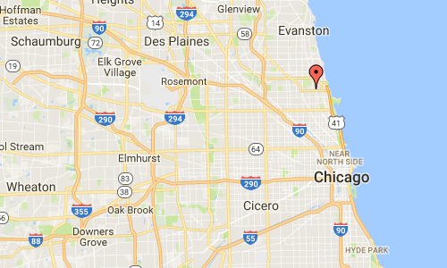
International Volvo Photo Locations Part 242
Click for Volvo Photography Locations Overview

2016 - Volvo XC90 at Swedish Bakery on 5348 N Clark St in Chicago USA

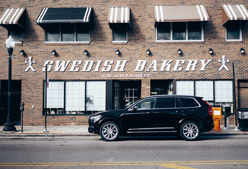
2016 – Volvo XC90 at Swedish Bakery on 5348 N Clark St in Chicago USA

2016 - Swedish Bakery on 5348 N Clark St in Chicago (Google Streetview)

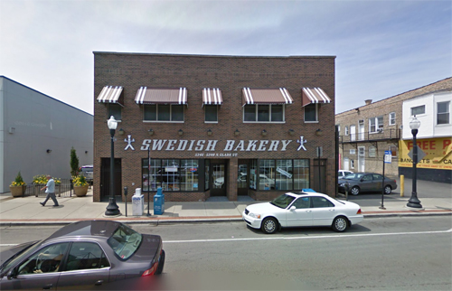
2016 – Swedish Bakery on 5348 N Clark St in Chicago (Google Streetview)

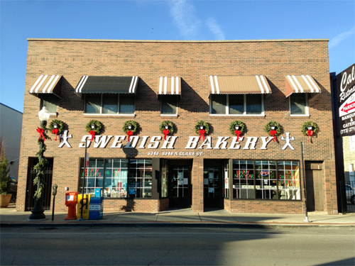
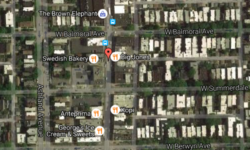
The Swedish Bakery is located on 5348 North Clark Street in Andersonville Neighborhood in Chicago, USA.

The Swedish Bakery is famous for specializing in Swedish coffeecakes, cookies, sweetrolls, toast, petit fours and marzipan cakes. We are known for using unique ingredients such as cardamom, saffron, anise, fennel, orange peel and almond paste. We are proud to offer our customers products that are never frozen or have any added preservatives.
We also offer a wide variety of Northern European and traditional American breakfast items, pastries, cookies and cakes for all occasions. A full list of our products and prices are available here.
Our most popular items are our Andersonville coffeecake, cardamom coffeecake, Swedish and butter cookies as well as our fruit glazed cake. Most of our products are offered for shipping within the Unites States. Please check our online shipping store for more information.

Andersonville is a neighborhood in western Edgewater / Uptown, Chicago. Once a sleepy little village made up primarily of Swedish immigrants, the community is particularly known for its diversity, including a continued Swedish cultural presence led by the Swedish American Museum, the Swedish Bakery and other Swedish businesses.
Swedish businesses include the bar Simon’s Tavern, a former basement speakeasy, which serves the Swedish wine drink as glögg, and Svea restaurants.
At one time there were more Swedes in Chicago than any city outside of Stockholm. Many of Andersonville’s Swedes were carpenters, contractors and architects, and played a significant role in building the city.

2016-swedish-bakery-in-chicago

Andersonville’s roots as a community extend well back into the 19th century, when immigrant Swedish farmers started moving north into what was then a distant suburb of Chicago. In the 1850s the area north of Foster and east of Clark was a large cherry orchard, and families had only begun to move into the fringes of what is now Andersonville. The neighborhood’s first school, the Andersonville School, was built in 1854 at the corner of those two thoroughfares, and served as the area’s primary school until 1908.

Today, in addition to being one of the most concentrated areas of Swedish culture in the United States, Andersonville is home to a diverse assortment of devoted residents and businesses, including one of Chicago’s largest gay and lesbian communities, a collection of Middle Eastern restaurants and bakeries, and a thriving Hispanic commercial area north of Catalpa Avenue.

2016-swedish-bakery-in-chicago-maps02

2016-swedish-bakery-in-chicago-maps01

More information at en.wikipedia.org and www.swedishbakery.com.

Volvo Photography Locations

Bhumi Farms in East Hampton – USA 🇺🇸

November 16th, 2016

International Volvo Photo Locations Part 241
Click for Volvo Photography Locations Overview

2016 - Volvo S90 at Bhumi Farms

2016 – Volvo S90 at Bhumi Farms on 131 Pantigo Rd in East Hampton, New York, USA

2016 - Bhumi Farms in East Hampton - USA (Google Streetview)

2016 – Bhumi Farms on Montauk Hwy / 131 Pantigo Rd in East Hampton, New York, USA (Google Streetview)

Bhumi Farm Stand is located at 131 Pantigo Road (Route 27) or the Montauk HWY in East Hampton on Long Island, New York.

This Bhumi Farm Stand offers Certified Organic produced grown directly from behind the stand, across the street, and from their own field located in Amagansett. They will also offer products made by local food artisans and fruit from the North Fork. Their promise is to only offer the freshest, most pristine vegetables possible.

2016-bhumi-farms-in-east-hampton-01

They grow using a strict organic protocol. They do not spray copper on their tomatoes or use plastic on the field. Bhumi Farms believe that food is meant to nourish, strengthen and heal, and this belief shapes our farming methods. Again this year, in addition to using essential oils to combat pests and fungus, they are remineralizing our soil with rock char. Minerals have been depleted from our soils, and need to be replenished to have healthy plants. These minerals will in turn be passed on to you, the consumer, through your diet.

2016-bhumi-farms-in-east-hampton-02

They will have tables around the property so you can sit and enjoy the backdrop of Sunflowers and Cosmos that will occupy the entire front acre of the property. Their hope is that the farm stand becomes a place where the community comes together to enjoy each other and this amazing place we call home.

The Village of East Hampton is a village in the town of East Hampton, New York, United States. It is located in Suffolk County, on the South Fork of eastern Long Island. The population was 1,083 at the time of the 2010 census, 251 less than in the year 2000. It is a center of the summer resort and upscale locality at the East End of Long Island known as The Hamptons and is generally considered one of the area’s two most prestigious communities.

2016-bhumi-farms-in-east-hampton-usa-maps02

2016-bhumi-farms-in-east-hampton-usa-maps01

More information at en.wikipedia.org, goop.com and www.bhumifarms.com.

Volvo Photography Locations

Brooklyn Bridge in New York – USA 🇺🇸

November 16th, 2016

International Volvo Photo Locations Part 240
Click for Volvo Photography Locations Overview

2016 - Volvo S60 on Brooklyn Bridge in New York, USA.

2016 – Volvo S60 on Brooklyn Bridge in New York, USA.

2004 - Volvo S40 on Brooklyn Bridge in New York.

2004 – Volvo S40 on Brooklyn Bridge in New York.

2016 - Brooklyn Bridge in New York (own photo)

2016 – Brooklyn Bridge in New York (own photo)

2016 - Brooklyn Bridge in New York (own photo)

2016 – Brooklyn Bridge in New York (own photo)

The Brooklyn Bridge is a hybrid cable-stayed/suspension bridge in New York City and is one of the oldest bridges of either type in the United States. Completed in 1883, it connects the boroughs of Manhattan and Brooklyn by spanning the East River. It has a main span of 486.3 m and was the first steel-wire suspension bridge constructed. It was originally referred to as the New York and Brooklyn Bridge and as the East River Bridge, but it was later dubbed the Brooklyn Bridge, a name coming from an earlier January 25, 1867, letter to the editor of the Brooklyn Daily Eagle and formally so named by the city government in 1915. Since its opening, it has become an icon of New York City and was designated a National Historic Landmark in 1964 and a National Historic Civil Engineering Landmark in 1972.

2016-brooklyn-bridge-in-new-york-03

The bridge originally carried horse-drawn and rail traffic, with a separate elevated walkway along the centerline for pedestrians and bicycles. Since 1950, the main roadway has carried six lanes of automobile traffic. Due to the roadway’s height (3.4 m posted) and weight (2,700 kg posted) restrictions, commercial vehicles and buses are prohibited from using this bridge. The two inside traffic lanes once carried elevated trains of the BMT from Brooklyn points to a terminal at Park Row via Sands Street. Streetcars ran on what are now the two center lanes (shared with other traffic) until the elevated lines stopped using the bridge in 1944, when they moved to the protected center tracks. In 1950, the streetcars also stopped running, and the bridge was rebuilt to carry six lanes of automobile traffic.

2016-brooklyn-bridge-in-new-york-maps02

2016-brooklyn-bridge-in-new-york-maps01

More information at en.wikipedia.org and www.history.com.

Volvo Photography Locations

Av des Hellènes in Beaulieu-sur-Mer – F 🇫🇷

November 16th, 2016

International Volvo Photo Locations Part 239
Click for Volvo Photography Locations Overview

1985 - Volvo 740 GLE on Avenue des Hellenes in Monaco

1985 – Volvo 740 GLE on Avenue des Hellènes in Beaulieu-sur-Mer in France

2016 - Avenue des Hellènes in Beaulieu-sur-Mer in France (Google Streetview)

2016 – Avenue des Hellènes in Beaulieu-sur-Mer in France (Google Streetview)

Beaulieu-sur-Mer is a seaside village on the French Riviera between Nice and Monaco. It is a commune in the Alpes-Maritimes department and borders the communes of Saint-Jean-Cap-Ferrat, Èze, and Villefranche-sur-Mer.

The Villa Kerylos is a structure on a low rocky promontory by the sea. It was built at the beginning of the 20th century by the archeologist Théodore Reinach and is in the style of an ancient Greek villa at the time of Pericles. The Villa was bequeathed to the Institute of France in 1928. It is currently classified as a historical monument.

Today Beaulieu-sur-Mer is known as a beautiful Mediterranean resort village with quality marina facilities. It is also known as the site of the Villa Kerylos, and a nice place for retirement.

Beaulieu-Sur-Mer served as the fictional town of “Beaumont-Sur-Mer” in the hit 1988 film Dirty Rotten Scoundrels.

2016-avenue-des-hellenes-in-beaulieu-sur-mer-maps02

2016-avenue-des-hellenes-in-beaulieu-sur-mer-maps01

More information at en.wikipedia.org and www.informationfrance.com.

Thanks to Per Pettersson for finding this Volvo Photo Location!

Volvo Photography Locations

Carltons Brasserie in Århus – DK 🇩🇰

November 15th, 2016

International Volvo Photo Locations Part 238
Click for Volvo Photography Locations Overview

1995 - Volvo 940 at Cartons Brasserie on Rosengade 23 i Århus, Denmark

1995 – Volvo 940 at Carltons Brasserie on Rosensgade 23 i Århus, Denmark

2016 - Carltons Brasserie on Rosensgade 23 in Århus- DK (Google Streetview)

2016 – Carltons Brasserie on Rosensgade 23 in Århus- DK (Google Streetview)

Carltons Brasserie is located at Rosensgade 23 in Århus, Denmark.

One of the old “players” in Aarhus, in the 80’s and 90’s the place to hang. They still keep the Bistro style and with a great decor and general a nice environment and design of the restaurant it all feels great and cozy. The food quality is high, and really good selections of wine etc. staff is super and all in all a really good experience, highly recommended. (www.tripadvisor.co.uk)

2016-carltons-brasserie-in-arhus-dk-facebook

Aarhus (officially spelled Århus from 1948 until 31 December 2010) is the second-largest city in Denmark and the seat of Aarhus municipality. It is located on the east coast of the Jutland peninsula, in the geographical centre of Denmark, 187 kilometres northwest of Copenhagen and 289 kilometres north of Hamburg, Germany. The inner urban area contains 264,716 inhabitants (as of 1 January 2016) and the municipal population is 330,639 (as of 2016). Aarhus is the central city in the East Jutland metropolitan area, which had a total population of 1.378 million in 2016.

The ARoS Art Museum, the Old Town Museum and Tivoli Friheden are among Denmark’s top tourist attractions. With a combined total of almost 1.4 million visitors they represent the driving force behind tourism but other venues such as Moesgård Museum and Kvindemuseet are also popular. The city’s extensive shopping facilities are also said to be a major attraction for tourists, as are festivals, especially NorthSide and SPOT. Many visitors arrive on cruise ships: in 2012, 18 vessels visited the port with over 38,000 passengers.

There are more than 30 tourist information spots across the city, some of them staffed, while others are on-line, publicly accessible touch screens. The official tourist information service in Aarhus is organised under VisitAaarhus, a corporate foundation initiated in 1994 by Aarhus Municipality and local commercial interest organisations.

2016-cartons-brasserie-in-arhus-dk-maps02

2016-cartons-brasserie-in-arhus-dk-maps01

More information at en.wikipedia.org and www.carlton.dk.

Thanks to Per Pettersson for finding this Volvo Photo Location!

Volvo Photography Locations

Neues Schloss on Schloßplatz in Stuttgart – D 🇩🇪

November 15th, 2016

International Volvo Photo Locations Part 237
Click for Volvo Photography Locations Overview

1973 - Volvo 164

1973 – Volvo 164

1973 - Volvo 164

1973 – Volvo 164

1973 - Volvo 164

1973 – Volvo 164

1973 - Volvo 164

1973 – Volvo 164

2016 - Das Neues Schloss in Stuttgart (Google Streetview)

2016 – Das Neues Schloss in Stuttgart (Google Streetview)

2016 - Das Neues Schloss in Stuttgart (Google Streetview)

2016 – Das Neues Schloss in Stuttgart (Google Streetview)

Das Neues Schloss is located at Schloßplatz 4 in Stuttgart in Germany.

Neus Schloss or The New Palace, one of the last large city palaces to be built in Southern Germany, is the magnificent 18th Century Baroque residence of the Kings of Württemberg from 1746 to 1797 and from 1805 to 1807 (often exchanging this honor with the nearby Ludwigsburg Palace). It was commissioned by the young Duke Carl Eugen of Württemberg, was built and modified by Nikolaus Friedrich Thouret, Leopold Retti, Philippe da la Guepière, Reinhard Heinrich Ferdinand Fischer. The palace is located on the southern edge of the Stuttgart Schlossplatz in the center of the city adjacent from the Old Castle on the Schillerplatz in front of the colossal Jubiläumssäule at the center of the Schlossplatz. Public tours of the building are only permitted by special arrangement, as the building contains some government offices.

2016-das-neues-schloss-in-stuttgart

Richard von Weizsäcker was born in an attic apartment of the New Castle on 15 April 1920. He was the president of the Federal Republic of Germany from 1984 to 1994.
The reconstruction of the castle followed the destruction thereof in 1944 from 1958 to 1964. Today the New Castle is the home of the ministries of the Baden-Wuerttemberg state government and representation rooms.

2016-das-neues-schloss-in-stuttgart-maps02

2016-das-neues-schloss-in-stuttgart-maps01

Thanks to Per Pettersson for finding this Volvo Photo Location!

More information at de.wikipedia.org and www.neues-schloss-stuttgart.de.

Volvo Photography Locations

The Two Byres in Waternish on Isle of Skye – UK

November 15th, 2016

International Volvo Photo Locations Part 236
Click for Volvo Photography Locations Overview
bookmark www.volvophotolocations.com today!

2016 – Volvo V90 Cross Country at The Two Byres or An Dà Bhàthach in Upper Halista on the Waternish peninsula on the Isle of Skye in Scotland

2016 – Volvo V90 Cross Country at The Two Byres or An Dà Bhàthach in Upper Halista on the Waternish peninsula on the Isle of Skye in Scotland

2016 - Volvo V90 Cross Country

2016 – Volvo V90 Cross Country at The Two Byres or An Dà Bhàthach in Upper Halista on the Waternish peninsula on the Isle of Skye in Scotland

2016 - The Two Byres

2016 – The Two Byres / An Dà Bhàthach in Waternish, Isle of Skye, Scotland (Google Streetview)

The Two Byres (“An Dà Bhàthach” in Gaelic) is a modern, eco-friendly house available for holiday lets on the Isle of Skye, rated 5 stars by Visit Scotland in 2014.

Set in the crofting community of Hallin, on the Waternish peninsula, the house faces out over Loch Bay and Loch Dunvegan and offers uninterrupted panoramic views stretching from the Cuillin mountain peaks, Macleod’s Tables, Dunvegan Head, the Minch all the way to the Outer Hebrides on the horizon.

The house is designed by local award winning architects to comfortably accommodate six, in light, spacious accommodation, in a resolutely modern wooden construction which blends more and more into the surrounding countryside as time and weather turn the larch cladding to silver.

Underfloor heating provides constant warmth and a wood-burning stove can be lit to give that extra touch. Three decks open the living areas out to make the most of the sea air from sunrise to sunset.

The house is equipped and maintained to the highest standards.

2016-the-two-byres-02

Waternish or Bhatairnis/Vaternish is a peninsula approximately 12 km long on the island of Skye, Scotland, situated between Loch Dunvegan and Loch Snizort in the northwest of the island, and traditionally inhabited and owned by Clan MacLeod whose clan seat is at the nearby Dunvegan Castle. The current clan chief is Hugh Macleod of Macleod. It contains the hamlets of Stein and Lusta in Loch Bay to the south east, Halistra, Hallin and Trumpan further north and Gillen to the west, all of which are accessed from the A850 road by crossing the Fairy Bridge. The highest point is Ben Geary (284 m) and the most northerly is Waternish Point. The name Waternish is derived from the Norse vatnenes or “headland of the pond”.

The history of the peninsula is a long (and often bloody) one involving clan feuds, massacres, de-population during the Highland Clearances, and eventual re-vitalisation. Originally consisting of small crofting communities, Waternish now has a growing population and is home to various arts and crafts enterprises. Whilst the main industry on Waternish is tourism, there has also been a revival in recent years of crofting or small-scale agriculture. The local school is called Knockbreck. The school has struggled recently due to an ageing population which has resulted in only 4 students currently attending and the school has been scheduled for closing in summer 2015. The local pub is the Stein Inn, which dates back to 1790 and is the oldest on Skye.

Trumpan was the site of the skirmish known as the Battle of the Spoiling Dyke and the churchyard is the burial ground of Rachel Chiesley, Lady Grange.

2016-the-two-byres-in-upper-halista-maps02

2016-the-two-byres-in-upper-halista-maps01

More information at en.wikipedia.org, www.thetwobyres.co.uk and www.visitscotland.com.

Volvo Photography Locations
bookmark www.volvophotolocations.com today!

Pointe Croisette in Cannes – F 🇫🇷

November 15th, 2016

International Volvo Photo Locations Part 235
Click for Volvo Photography Locations Overview
bookmark www.volvophotolocations.com today!

1985 - Volvo 780 at Boulevard de la Croisette on Pointe Croisette in Cannes, France

1987 – Volvo 780 at Boulevard de la Croisette on Pointe Croisette in Cannes, France 🇫🇷. Great photography for Volvo Cars by Thomas Dirk Heere !📸👍

1985 – Volvo 780

1987 – Volvo 780 at Boulevard de la Croisette on Pointe Croisette in Cannes, France 🇫🇷. Great photography for Volvo Cars by Thomas Dirk Heere !📸👍

2019 – Pointe Croisette in Cannes, France (Google Streetview)

2019 – Pointe Croisette in Cannes, France (Google Streetview)

2019 – Pointe Croisette in Cannes, France (Google Streetview)

Pointe Croisette is one of the ten districts of the city of Cannes, so called because it includes the part of the Boulevard de la Croisette which continues on the cape after skirting the city center.

The cape extends into the Mediterranean, surrounded on the west by the bay of Cannes and on the east by the Gulf of Juan. It faces, facing south, the Lérins Islands, a stone’s throw away.

From the Pointe Croisette, you have a wonderfull view on Cannes!

The Promenade de la Croisette or Boulevard de la Croisette, is a prominent road in Cannes, France. It stretches along the shore of the Mediterranean Sea and is about 2 km long. The Croisette is known for the Palais des Festivals et des Congrès, where the Cannes Film Festival is held. Many expensive shops, restaurants, and hotels (such as the Carlton, Majestic, JW Marriott Cannes, and Martinez) line the road. It goes completely along the coastline of Cannes.

The Croisette is listed in the cultural heritage general inventory of France.

Cannes is a city located on the French Riviera. It is a commune located in the Alpes-Maritimes department, and host city of the annual Cannes Film Festival, Midem, and Cannes Lions International Festival of Creativity. The city is known for its association with the rich and famous, its luxury hotels and restaurants, and for several conferences. On 3 November 2011 it also played host to the G20 organisation of industrialised nations.

The Promenade de la Croisette is the waterfront avenue with palm trees. La Croisette is known for picturesque beaches, restaurants, cafés and boutiques. Le Suquet, the old town, provides a good view of La Croisette. The fortified tower and Chapel of St Anne house the Musée de la Castre. A distinctive building in Cannes is the Russian Orthodox church.

More information at fr.wikipedia.org/wiki/La_Croisette and www.cannes-destination.com.

Volvo Photography Locations
bookmark www.volvophotolocations.com today!

Kungsbacka Golfklubb in Särö 🇸🇪

November 13th, 2016

Volvo Photo Locations Part 251
Historic Volvo Photography Locations Overview

1985 - Volvo 760 GLE at Kungsbacka Golfklubb

1985 – Volvo 760 GLE at Kungsbacka Golfklubb att Hamravägen 15 in Särö

2016 - Kungsbacka Golfklubb in Särö

2016 – Kungsbacka Golfklubb in Särö

2016 - Kungsbacka Golfklubb in Särö

2016 – Kungsbacka Golfklubb in Särö

Kungsbacka Golfklubb is located alongside the 158 road between Västra Frölunda in Göteborg and Kungsbacka (Onsala) in Särö.

Kungsbacka Golf Club was founded in 1970 and is located on land that is belonged to Hamra Gård, which was separated from Vallda Säteri during the First World War.

2016-kungsbacka-golfklubb-in-saro-03

The area is located between the sea, Sandö in the West, Hördalen in the north and Vallda in the south.

The British golf course architect Frank Pennink was commissioned to design the first 13 holes when it was possible to be constructed. These were ready for golf play in 1974. In 1978, the 18-hole course was completed with the last five holes.

2016-kungsbacka-golfklubb-in-saro-maps02

2016-kungsbacka-golfklubb-in-saro-maps01

More information at www.kungsbackagk.se and www.hamragard.se.

Thanks to Per Pettersson for finding this Volvo Photo Location!

Volvo Photo Locations

Delsjö Golfklubb in Göteborg 🇸🇪

November 12th, 2016

Volvo Photo Locations Part 250
Historic Volvo Photography Locations Overview

1972 - Volvo 142GL at Delsjö golfklubb on Gamla Boråsvägen in Göteborg

1972 – Volvo 142 GL at Delsjö golfklubb on Gamla Boråsvägen in Göteborg, thanks to Per Pettersson!

2016 - Delsjö golfklubb on Gamla Boråsvägen in Göteborg

2016 – Delsjö golfklubb on Gamla Boråsvägen in Göteborg

Delsjö Golfklubb is located on Gamla Boråsvägen in Göteborg, Sweden.

The club was founded in 1962 and is one of the oldest golf clubs in Gothenburg. The course is situated in the beautiful natural reserve “Delsjöområdet”.
The course was designed by Douglas Brasier and Frank Pennink and opened in 1965.

2016 - Delsjö golfklubb on Gamla Boråsvägen in Göteborg

2016 – Delsjö golfklubb on Gamla Boråsvägen in Göteborg

The greens and the surrounding areas were redesigned in 2004 by Peter Chamberlain, and today it is one of very few courses in Sweden managed in an entirely environmental manner. The guests are often thrilled by an interesting and challening golf course even though the overall length of the course isn’t very extensive. The new greens present a challenge for all golfers!

The newly renovated clubhouse offers a fantastic restaurant including a pro shop, conference facilities and lockerrooms with sauna.

In 2009 Delsjö GK was rated as the 32nd best golf course in Sweden by Golf Digest. The club also offers corporate days, golf clinics and much more.

Delsjö GK truly is a great golfing experience!

2016-delsjo-golfklubb-maps02

2016-delsjo-golfklubb-maps01

More information at delsjogolfkrog.se and www.degk.se.

Thanks to Per Pettersson for finding this Volvo Photo Location!

Volvo Photo Locations