April 5th, 2012
Volvo Photo Locations Part 87


2013 – Volvo S60 on Fendergatan & Henriksdalskajen in Hammarby Sjöstad in Stockholm 🇸🇪
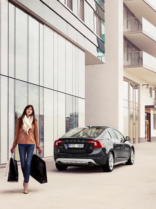
2013 – Volvo S60 on Fendergatan & Henriksdalskajen in Hammarby Sjöstad in Stockholm 🇸🇪
2021 – Fendergatan & Henriksdalskajen in Hammarby Sjöstad in Stockholm (Google Streetview)

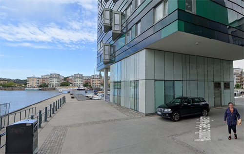
2012 – Fendergatan & Henriksdalskajen in Hammarby Sjöstad in Stockholm (Google Streetview)
Hammarby Sjöstad is a part of Stockholm municipality, currently undergoing major urban redevelopment. It is located on both side of lake Hammarby sjö, bordering Nacka Municipality to the east. The area is part of the districts Södermalm and Södra Hammarbyhamnen.
Before the current redevelopment began, the area was known as Norra Hammarbyhamnen and Södra Hammarbyhamnen, a mainly industrial zone, centered around the Lumafabriken works, a piece of functionalist architecture designed by Eskil Sundahl and Arthur von Schmalensee which now houses a library and offices. The neighbouring Lugnet was a run-down light industrial area, housing an impromptu trailer park. On the north side of the lake, the Norra Hammarbyhamnen area was used as a harbour area, with a railway connecting the area.
New plans for most of the Södermalm area Norra Hammarbyhamnen in the early 1990s opened the door for a redevelopment of the entire area around the water expanse Hammarby Sjö. A general plan, featuring an extension of the Tvärbanan light rail link from Gullmarsplan through the area was presented.
Although the south and east part of Hammarby Sjöstad is located outside what is traditionally considered to be the perimeter of inner-city Stockholm, the design is intentionally urban rather than suburban, with boulevards, clearly defined and architecturally varied city blocks, and commercial spaces in the ground floor of the buildings. The location, next to the lake Hammarby Sjö and a canal, Sickla Kanal, has allowed for plenty of quays and walkways along the water.
At the place where the Volvo photo was taken, restaurant Zee is located.

More information on www.hammarbysjostad.se and Zee the Restaurant
Filed in cars,sweden,volvo photo locations,weblog
- Tags: Hammarby Sjöstad, S60, Stockholm, Volvo
-
0 Comments
April 5th, 2012
Volvo Photo Locations Part 86

1961 – Volvo P1800 at Nya Ullevi Stadion in Göteborg

2012 – Ullevi Stadion in Göteborg (Google Streetview)
Ullevi is a large stadium in Göteborg. The stadium was built for the 1958 FIFA World Cup, but since then Ullevi has also hosted the 1995 World Championships in Athletics and the 2006 European Championships in Athletics, the UEFA Cup Winners’ Cup finals in 1983 and 1990, the UEFA Euro 1992 final, the UEFA Cup final in 2004, and annually hosted the opening ceremony of the Gothia Cup—the world’s largest football tournament.
The stadium is the biggest in Scandinavia, with a seating capacity of 43,000 and a total capacity of 75,000 for concerts.
The Ullevi stadion was for a while called Nya Ullevi (New Ullevi), since close by was the former Gamla Ullevi (Old Ullevi) stadion. But recently, the Gamla Ullevi stadion was rebuilt, but kept the ‘old name’.
The statue in front of the stadium is of boxing legend Ingo Johansson.
Ingemar Johansson (September 22, 1932 – January 30, 2009) was a Swedish boxer and former heavyweight champion of the world. Johansson was the fifth heavyweight champion born outside the United States. In 1959 he defeated Floyd Patterson by TKO in the third round, after flooring Patterson seven times in that round, to win the World Heavyweight Championship. As a result, Johansson won the Hickok Belt as top professional athlete of the year and was named the Associated Press Male Athlete of the Year and Sports Illustrated magazine’s “Sportsman of the Year”.
In 2000, the Swedish Sports Academy selected Johansson as Sweden’s third-best athlete of the 20th century, behind tennis great Björn Borg and Alpine skiing great Ingemar Stenmark.

More information on www.goteborg.com
Filed in cars,sweden,weblog
- Tags: Göteborg, Ullevi, Volvo
-
0 Comments
April 5th, 2012
Volvo Photo Locations Part 109

1966 – Volvo Amazon Estate (P220)

1967 – View diagonally across Mäster Samuelsgatan with the shops Gulins and Stridsbergs Päls at kv Beridarebanan. (Stockholmskällan)

2012 – Mäster Samuelsgatan (corner with Slöjdgatan) in Stockholm (Google Streetview)
Master Samuelsgatan is a street in the district Norrmalm in Stockholm. It extends east-west from Birl Jarlsgatan to Vasagatan and is about 1000 meters long.
The name comes from the vicar of Klara and Bromma congregations named Samuel Hammarinus (who died in 1667). He owned a plot in the quarter Svanen near Långbrogatan.
At the transformation of downtown Stockholm in the 50’s and 60’s, changed street appearance significantly when Sveavägen would be drawn up to Sergel Torg. Today is Master Samuelsgatan connected with bridges over Sveavägen and Sergelgatan, when these were lowered about 5 feet in the Hötorgscitys inception in 1950 – and the 60’s. The Klara Tunnel, which the City Plan 1967 would be further east, stops now at Mäster Samuelgatan eastern part.

More information on sv.wikipedia.org
Filed in cars,sweden
- Tags: Stockholm, Volvo
-
0 Comments
April 5th, 2012
Volvo Photo Locations Part 80

1953 – Volvo PV445 Duett at Doktor Bex gata in Göteborg 🇸🇪.
1953 – Volvo Duett at Doktor Bex gata in Göteborg 🇸🇪.

1953 – Volvo Duett at Doktor Bex gata in Göteborg 🇸🇪.

1955 – Volvo Duett at Doktor Bex gata in Göteborg 🇸🇪.

1953 – Volvo Duett at Doktor Bex Gata in Göteborg

1992 – Volvo 960 on Doktor Bex Gata in Göteborg
Photographer John-Erik Andersson (from Studio Wezäta) made the original photos in 1953, here back at the location for a remake with a new Volvo 960 for the Volvo magazine Ratten 3/92.

1953 – Volvo Duett at Doktor Bex gata in Göteborg 🇸🇪.

2007 – Volvo XC90 at Doktor Bex gata in Göteborg 🇸🇪.

Remake for Ventilen magazine 2013 #2 from 2013 with Volvo Duett at Doktor Bex gata in Göteborg 🇸🇪.

2012 – Doktor Bex Gata in Guldheden in Göteborg (Google Streetview)
Doktor Bex Gata is a street located on the Guldheden in Göteborg.
The street is named in memory of Abraham Bex (who died in mid-October 1696) and who became a doctor of medicine in Utrecht (Netherlands) in 1680 and stadsfysikus (town doctor) in Göteborg around 1685.

1951 – Doktor Bex Gata in Guldheden in Göteborg
In this street there is a series of unusual retail buildings from 1951 located (as seen above). They were designed by architect Henning Orlando and built in 1950-1951. Konsum (today Coop) was one of the first tenants at number 4 in november 1951. Other tenants were: Rolf Nilsson’s fish shop, Gullbergs paint and chemicals trade, Mr Wenner Sten’s photographic studio, Ebba Edwalls hairdresser, Guldhedens Dry and a post office.
In the summer of 1953 Volvo used this street with shop buildings in their campaign for the Volvo Duett.
In 2007, Volvo revisited the site in their Classics for the future campaign.

2024 – Volvo Photo Locations revisited, here a wonderful Volvo 142 at Doktor Bex gatan in Göteborg.

More information at wikipedia .com
Filed in weblog
- Tags: Duett, Göteborg, P445, PV445, Volvo, XC90
-
0 Comments
April 5th, 2012
International Volvo Photo Locations Part 257

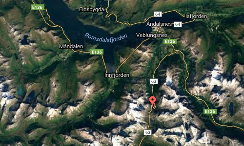
2011 – Volvo V60 R-Design at Trollstigen or Road 63 in Åndalsnes Norway 🇳🇴

2012 – Trollstigen Mountain Road in Norway (Google Streetview)

2019 – Volvo S60 T6 AWD R-Design at Trollstigen or Road 63 in Åndalsnes Norway 🇳🇴

2019 – Trollstigen or Road 63 in Åndalsnes (Google Streetview)
The Trollstigen Mountain Road is one of Norway’s most dramatic and most visited attractions.
Trollstigen is located approximately 15 kilometres south of Åndalsnes in the county of Møre og Romsdal, north in Fjord Norway. The region centre is Molde (25,000 inhabitants), which is the largest town in the area.
Trollstigen has a steep incline of 9 percent and consists of 11 hairpin bends up a steep mountainside. Encircling the road are lofty mountains. Names such as Kongen (the King), Dronningen (the Queen) and Bispen (the Bishop) confirm their majesty.
The six-kilometre long Trollstigen Mountain Road is normally open from mid-May to sometime in October, depending on when the snow arrives and when it melts.
The Trollstigen Mountain Road is part of RV 63 in Rauma in Romsdal, Møre og Romsdal. The road connects Åndalsnes and Romsdal with Valldal and Sunnmøre.
Vehicles more than 12.4 metres long are not allowed on Trollstigen.
Trollstigen was opened on 31 July 1936 by King Haakon VII. The road took eight years to build. Even today, the road is a good example of the art of engineering and construction.
The old Kløvstien Track at Trollstigen has for hundreds of years been an important link between Romsdalen and Sunnmøre. The newly restored Kløvstien path is now a popular hiking goal.
You can reach Trollstigen and Romsdal by car, it takes six hours from Oslo or four hours from Trondheim. From Oslo you drive up Gudbrandsdalen to Dombås, then down Lesja and Romsdal to Åndalsnes. From Trondheim you drive via Dovrefjell to Dombås and down the same way via Romsdal to Åndalsnes.


More information on www.visitnorway.com (The Trollstigen Mountain Road)
Filed in cars,norway,volvo photo locations
- Tags: Norway, R-Design, Trollstigen, Volvo, Volvo S60, volvo V60
-
0 Comments
April 5th, 2012
Volvo Photo Locations Part 77

2012 – Volvo V60 D6 Plug-in Hybrid Pure Limited at Avalon Hotel on Kungstorget in Göteborg, Sweden 🇸🇪.

2009 – Volvo C30 Drive Electric at Avalon Hotel on Kungstorget in Göteborg, Sweden 🇸🇪.

2009 – Volvo C30 Drive Electric at Avalon Hotel on Kungstorget in Göteborg, Sweden 🇸🇪.

2012 – Kungstorget in Göteborg (Google Streetview)
Kungstorget is a square in the centre of Göteborg. At this square you’ll find the famous market hall Saluhallen Kungstorget, inaugurated in 1889. Kungstorget has always been a market square.
The Volvo is standing in front of the famous Hotel Avalon, a four star design hotel with a rooftop pool and terrace.

Filed in cars,photography
- Tags: Göteborg, Volvo
-
0 Comments
April 5th, 2012
International Volvo Photo Locations Part 256

2013 – Volvo S60

2013 – Volvo S60

2012 – Otrøya Island in Norway (Google Streetview)
Road 668 in Setbukta is a location on Otrøya (sometimes called Otterøya), which is the largest island of the municipality of Midsund in Møre og Romsdal county in Norway. The 75.5-square-kilometre island sits at the entrance to the Romsdalsfjord. The highest point is Oppstadhornet at 737 metres above sea level.
On the east end of the island, there is a ferry connection across the Julsund strait to the village of Mordal in Molde.
Midsund is an island municipality southwest of Molde. The municipality consists of the two mountainous islands Otrøya and Midøya, and some smaller islands, 94 km2 in total. Dominating mountains up to 740 metres above sealevel covers 80% of the surface area. Fishing, aquaculture, agriculture and industry has given grounds for settlement and development in the island community. There are bridges between the islands, and a ferry connection to the mainland. The fishing possibilities in Midsund are particularly good, both from land and from boat. There are several cabin centres that offers fishing holidays here. A visit to the caves Franskhelleren and Bjørneremshellerne is an experience, and the old mill in the Heggdalsvika bay is a well preserved memorial from the 1880s. A mountain hikingtrip on foot in the summer or on ski in the wintertime gives you a fantastic view over Midsund and the region.
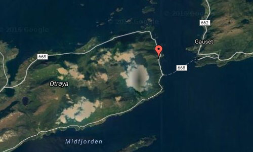

More information on wikipedia.org, Tour suggestion by car: Island hopping round Ona and www.visitnorway.com
Filed in cars,norway,volvo photo locations
- Tags: Norway, Otrøya, Volvo
-
0 Comments
April 5th, 2012
Volvo Photo Locations Part 79

2011 – Volvo C30 at Sahlgrenska huset on Norra Hamngatan in Göteborg 🇸🇪.

2012 – Sahlgrenska huset on Norra Hamngatan in Göteborg (Google Streetview)
The building pictured above is the Sahlgrenska huset.
On the night of January 14, 1746 a fire that destroyed 196 private houses and farms in this area. The plot had then one building made of solid stone, bought in 1721 by Jacob Sahlgren († 1736). The house was damaged, however, so important to widow Brigitta Sahlgren, decided to build a new one, which was finished in 1753. The drawings were probably carried out by the city architect Bengt Wilhelm Carlberg. The next owner was a merchant Carl Emil Billqvist (1817-1895), who in 1856 ordered from architect Adolf Edelsvärd plans for a renovation. According to Bill Qvist’s wish they changed the facade towards the water, entrance stairs with lampposts and railings of cast iron. Large change where made to the building.
Today, Göteborg city owns the house since 1905. A major facade renovation carried out in 1991 and 1994, there was an interior remodeling. Västra Götaland Regional Council (or Regionens Hus – Västra Götalandsregionen) is located in this building today. Region Västra Götaland’s assignment is to contribute to a thriving Västra Götaland which is a good place to live and work. It must be a good place for future generations to grow up in. Region Västra Götaland is governed by democratically elected politicians and with just over 50,000 employees is one of Sweden’s biggest employers.

Filed in cars,sweden,volvo photo locations
- Tags: C30, Göteborg, Volvo
-
0 Comments
April 5th, 2012
Volvo Photo Locations Part 76

1961 – Volvo 121 & 122 Amazon

2012 – Kungsgatan in Stockholm (Google Streetview)
Kungsgatan is a famous and popularstreet in central Stockholm.
The street crosses Vasagatan, Drottninggatan, and Sveavägen and ends at Stureplan. Two streets pass over Kungsgatan: Malmskillnadsgatan on Malmskillnadsbron bridge and Regeringsgatan on the Bridge of Regeringsgatan. The last bridge with Regeringsgatan is shown in this photo.
Kungsgatan was dug through the Brunkebergsåsen esker (a natural ridge) in the early 20th century and inaugurated in 1911. Today it is a lively shopping street flanked by cinemas, cafés, and other shopping facilities.

Filed in cars,photography
- Tags: Kungsgatan, Stockholm, Volvo
-
0 Comments
April 4th, 2012
Volvo Photo Locations Part 104

2000 – Volvo S60

2012 – Fjällgatan in Stockholm (Google Streetview)
Fjällgatan is a street on Södermalm in Stockholm. It lies on Stigberget between Erstagatan and Renstiernas gata near Katarinavägen. The street is 27.8 meters above the sea level. The street is known for the beautiful view of Saltsjön, and it also has great views of Stockholm’s most central parts, from Gamla Stan to Djurgården with Gröna Lund.
Historic environment located high up on the edge of a cliff with a fantastic view of the city. Fjällgatan’s Kaffestuga café is charming and popular.
The blocks around Fjällgatan, Stigbergsgatan, Mäster Mikaels Gata, Fiskargatan, and Södra Teatern are lined with well-preserved wooden buildings from the 1700s on one side and a magnificent view on the other.

More information on www.visitstockholm.com
Filed in cars,sweden
- Tags: Stockholm, Volvo
-
0 Comments


 Posts
Posts