home

[ Content | Sidebar ]

Hotel des Indes in The Hague – NL 🇳🇱

March 4th, 2016

International Volvo Photo Locations Part 179
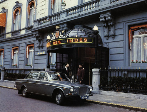
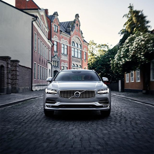
Click for Volvo Photography Locations Overview

1970 - Volvo 164

1970 – Volvo 164

2016 - Hotel des Indes at Lange Voorhout in The Hague, The Netherlands (Google Streetview)

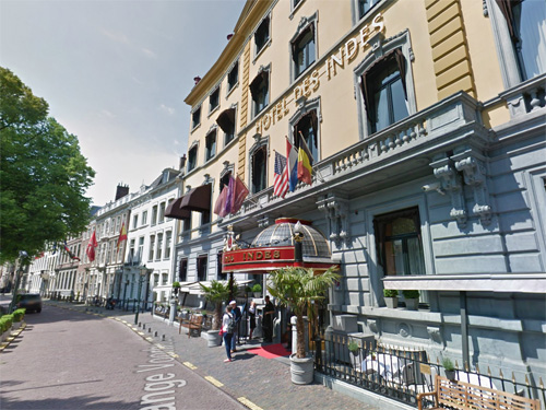
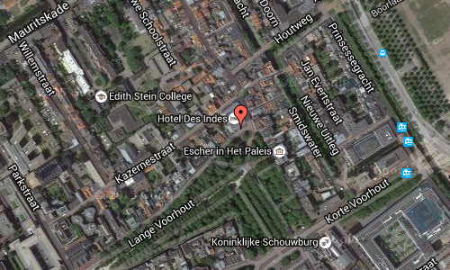
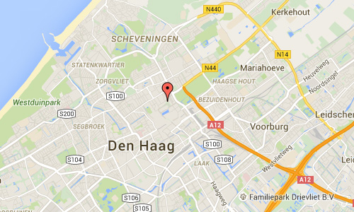
2016 – Hotel des Indes at Lange Voorhout in The Hague, The Netherlands (Google Streetview)

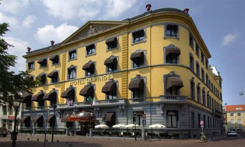
Hotel Des Indes is a hotel at the Lange Voorhout in The Hague or Den Haag. It was built in 1858 a a family house. From 1881 a hotel is located in the building.

Hotel Des Indes is located in a beautiful area in the city centre of the Hague. The surrounding buildings make up the government and diplomatic district. Visit the Royal Art Gallery Mauritshuis to see the works of Vermeer and Rembrandt or the Escher Museum located in the Winter Palace, both within walking distance of the hotel.

The palace was built in 1858 for W.D.A.M. Baron Brienen of Groote Lindt (1814-1863), a personal advisor of King William III, who was often in The Hague. The baron bought three houses on the site of the Lange Voorhout and the Vos in Tuinstraat and demolished them. One of them, was the William II museum, which stood on the corner of the Denneweg. In this place he built a palace for the sum of 150,000 guilders by architect Arend Roodenburg. The baron would have a palace in the Hague there to give parties. The house had a spacious courtyard, stables, servants and private residences and a magnificent ballroom. One could by the current entrance to the carriage drive inside, and then the coach at the roundabout could, where high tea is served now, turning to leave the premises again.
After the death of the baron in 1863 it came into the possession of his son Arnold, but four years later the building was sold. The palace was owned by hotelier Paulez who gave it to his daughter, she made with her husband Friedrich Wirtz a hotel.

The palace underwent a four-year renovation and was opened on May 1, 1881 by Prince Frederik, the uncle of King William III. The hotel had 120 rooms in the early years, there was only one bathroom per floor, but at that time was already a luxury. Des Indes was true back then as a hotel with sophisticated elegance. The early years spent a lot of lavish parties and exclusive banquets. The hotel also had difficult times, but then in 1899 the first peace conference was held on the initiative of Tsar Nicholas II, in The Hague, took the arrival of many diplomats and government leaders for a significant upturn.

In 1896, C. F. Haller followed director Wirtz, and this was followed in 1914 by Mrs. M. F. Haller-Rey and her brother Monegasque Jean-Jacques Rey. However, the First World War threw a spanner in the works, and the hotel almost went under. In 1918 the shares for 1.25 million guilders were taken over by the Dutch Export Company (N.U.M.), who wanted to establish an office in the building. At the behest of Mayor J.A.N. Patijn the palace, however, was (with a small profit: 85,000 guilders) sold to the Dutch State, so the property could remain as high quality hotel. Rey was appointed as manager.

In 1971, threatened to close the hotel. Prime Minister Biesheuvel, who, like Schmelzer and Tilanus almost weekly ate their lunch there, would dine there for the last time with his ministers on 27 October 1971. They decided to act and in 1972 Julius Verwoerdt took over the operation in hand. Soon after Verwoerdt bought the property from the State of the Netherlands for 1.38 million guilders. Under the leadership of an old relationship Verwoerdt, Altkemper construction coordinator and director Hans Haan later years took an intensive renovation site. The antiquated coal furnace was replaced in the restaurant kitchen and the barely functioning central (steam) heating. The total electrical wiring was redone after which the remaining funds to the famous central hall and rooms were refurbished.

2016 - Hotel des Indes

In 1979 Verwoerdt sold his shares in the now grown to 13 hotels and led by Gerard van der Veen standing hotel empire to the British hotel subsidiary of Bass Breweries Crest Hotels.
In 2004 the hotel had 76 more rooms. Since January 2003 the hotel is part of the hotel chain Starwood Hotels and Resorts Worldwide, under the name of The Luxury Collection. In this chain are also among others Sheraton, Le Meridien and St. Regis. This hotel group has carried out a complete renovation of the hotel, which added an extra floor in 2005 and 2006. The white facade is painted yellow. Shortly before the summer of 2006 the hotel opened up again. The French interior designer Jacques Garcia, responsible for the design of the new interior.

2016 - Hotel des Indes Den Haag Maps02

2016 - Hotel des Indes Den Haag Maps01

More information on www.hoteldesindesthehague.com and nl.wikipedia.org.

Volvo Photography Locations

Kiliansgatan in Lund 🇸🇪

March 4th, 2016

Volvo Photo Locations Part 197
Historic Volvo Photography Locations Overview

2016 - Volvo V90

2016 – Volvo V90

2016 - Kiliansgatan in Lund (Google Streetview)

2016 – Kiliansgatan in Lund (Google Streetview)

Kiliansgatan is a street in the central parts of Lund. The street begins at Mårtenstorget, passes Magle Lilla Kyrkogata, Skomakargatan and Magle Stora Kyrkogata and ends at the Lund Cathedral. Further up the street is the small street buildings. Larger buildings along the street is Sankt Mikael, Folkets hus/Lunds Stadsteater and the youth center Hemgården. Even Lunds Dans- och Musikalgymnasium has its address on the street.

2016 - Kiliansgatan in Lund Maps02

2016 - Kiliansgatan in Lund Maps01

More information at sv.wikipedia.org and kulturportallund.se.

Historic Volvo Photography Locations Overview

SAS Royal Hotel at Hammerichsgade in Copenhagen – DK 🇩🇰

March 2nd, 2016

International Volvo Photo Locations Part 178
Click for Volvo Photography Locations Overview

1961 - Volvo P1800

1961 – Volvo P1800

1961 – Volvo PV544 at Royal Hotel in Copenhagen

2016 - Radisson Blu Royal Hotel at Hammerichsgade 1 in Copenhagen (Google Streetview)

2016 – Radisson Blu Royal Hotel at Hammerichsgade 1 in Copenhagen (Google Streetview)

2016 - Radisson Blu Royal Hotel at Hammerichsgade 1 in Copenhagen (Google Streetview)

2016 – Radisson Blu Royal Hotel at Hammerichsgade 1 in Copenhagen (Google Streetview)

The Radisson Collection Royal Hotel (previously known as the Royal Hotel) at Hammerichsgade in Copenhagen. It is located in the heart of the city, in the Vesterbro district, close to Tivoli and the central station. On a road island outside the hotel is the “Freedom Statue”, commemorating the abolition of serfdom in Denmark.

With stunning architecture designed by Danish architect Arne Jacobsen, the Radisson Blu Royal Hotel, Copenhagen is one of the premier places to stay while visiting Denmark’s capital city. Copenhagen guests marvel at the hotel’s spiral staircase and reflective façade, complimented by sleek, modern furnishings and decor throughout the building. A total of 260 rooms and suites boasts striking details and thoughtful amenities like Free high-speed, wireless Internet access, coffee and tea provisions, and 24-hour room service. Dine in style at the Alberto K, our 20th-floor restaurant that overlooks the beautiful city, or stop in to the Café Royal for a more relaxed meal. Our exceptional fitness center includes dry and steam saunas and massage services. Meeting facilities are also available for up to 300 guests for a variety of events.

2016 - Royal Hotel 01

The Radisson Blu Royal Hotel is a historic hotel in Copenhagen, that was designed by Danish architect and designer Arne Jacobsen for the airline Scandinavian Airlines System (SAS) between 1956 and 1960. Built as the SAS Royal Hotel, the hotel was renamed the Radisson SAS Royal Hotel in 1994, when SAS bought a share in the foreign division of Radisson hotels. When SAS sold their share in 2009, it was renamed the Radisson Blu Royal Hotel, its current name.

At its completion the hotel was the largest in Denmark, at 69.60 meters in height, the first skyscraper in Copenhagen until 1969 and at the same time the tallest building in Denmark. In 2009, it was the seventh highest tower in Denmark.

1955 - SAS Royal Hotel model presentation attended by Arne Jacobsen and Alberto Kappenberger

1955 – SAS Royal Hotel model presentation attended by Arne Jacobsen and Alberto Kappenberger

The entire hotel – from the exterior façade through to the stainless-steel cutlery used in the restaurant and the Swan and Egg chairs gracing the lobby – was designed by famous Danish architect, Arne Jacobsen. Since most of his work has been replaced by corporate standard fabrics and furniture, the hotel is referred to as Jacobsens’ Lost Gesamtkunstwerk. Only a single room has been kept in the original design. It has all of the original, green furniture and the wood panels on the wall. This room, with the number 606, is still available for booking.

Shades of green dominate the entire design. Jacobsen, who was also working as a landscape architect 1955-1960, pursued a “modern garden” theme. He implemented this theme using green textiles and furniture combined with “organic shapes” and rigid geometric forms.

2016 - Royal Hotel 03

Jacobsen has created several furniture, lighting and textile designs. Some models were later adopted into mass production and have become design classics, which are exhibited in museums worldwide. Others, however, remained unique pieces.

During the design phase sketches of the building where published in Danish newspapers. Critics feared a destruction of the traditional skyline of Copenhagen. The building was compared to a punch card. Jacobsens response was: “it’s funny, for that is actually what it looks like when the windows are open on a hot summer’s day.” Another term used was introduced by Jacobsens former associate Erik Møller, who called it the ‘glass cigarbox’. The promoter of the international style, Philip C. Johnson, said it was the worst copy of Lever House. Jacobsen responded: “At least, it came in first when they held a competition for the ugliest building in Copenhagen.”

The structure is twenty stories high and a defining characteristic of Copenhagen’s skyline. The structure was inspired by New York Park Avenue structures, namely Skidmore, Owings and Merrill’s Lever House. The building’s sense of lightness emanates from its Lever House-inspired form with a two-story base supporting its lofty “punch card” tower.

2016 - Royal Hotel 02

The reinforced concrete frame structure erected in the tower has a curtain wall of aluminum profiles and transparent green and gray anodized glass. The windows can be opened to the inside stories in all. The horizontal distance between the aluminum profiles is 60 cm. Vertical take turns green glass followed by 168 cm 120 cm window is installed. The curtain wall construction Jacobsen at the three-story City Hall was first used in 1955 Rødovre Denmark. The hotel façade differs only from the City Hall by the light green colour of the intermediate elements and some slightly different proportions.

2016 - Royal Hotel Maps02

2016 - Royal Hotel Maps01

More information on www.radissonblu.com, projects.vanartgallery.bc.ca and en.wikipedia.org.

Volvo Photography Locations

Panoramavägen in Göteborg 🇸🇪

March 2nd, 2016

Volvo Photo Locations Part 196
Historic Volvo Photography Locations Overview

2010 - Volvo C30

2010 – Volvo C30

2010 - Volvo C30

2010 – Volvo C30

2010 - Volvo C30

2010 – Volvo C30

2016 - Panoramavägen in Göteborg (Google Streetview)

2016 – Panoramavägen in Göteborg (Google Streetview)

2016 - Panoramavägen in Göteborg (Google Streetview)

2016 – Panoramavägen in Göteborg (Google Streetview)

Panoramavägen (Panorama road) is a street in Keillers Park on Ramberget on Hisingen Island, in the north of Göteborg.

Ramberget (English: Raven Hill) is a mountain on Hisingen island in Gothenburg, Sweden. The surrounding area and park is called Keillers Park. Ramberget is a popular tourist attraction and a place for outdoor recreation for Göteborg residents, with walking paths, lookouts over the city of Göteborg and artworks. Ramberget is with its highest point 87 metres above sea level, with a lower second point called Ättestupan. There is a road for cars going to the top of Ramberget. The park is about 31 hectares.

Ramberget got its characteristic shape already during the Ice Age 12,000 years ago. The northeast slope is flat while the south side has a higher cliff that is clearly visible from the river. The ice sheet has left traces both in the rock faces and through boulders in the area. Ramberget got its name of the old Swedish word “ram” which means raven. Ravens are still nesting on Ramberget. Until the early 1800s, when it wood was still widely used as fuel, there was no trees on Ramberget which instead was covered with heather, later replanting made the wood grow back and today there is a lush vegetation of beech, larch, pine and oaks. Most of the north shore of the river, including the area around Ramberget, was owned in the early 1900s by the Keiller family. Alexander Keiller, who came to Göteborg from Scotland, had in the 1840s started a mechanical workshop that would later evolve into shipbuilding group Götaverken. During the recession of the 1860s, however, the company went into bankruptcy and after reorganization was Alexander’s son James Keiller new manager. After some setbacks, including a severe fire in 1898, so James decided to pull back from the shops. 1906, he sold almost all of the business and in the same time he donated the area around Ramberget to the city, with the condition that the area would be used and remain a natural park. The deed of gift is that only buildings that are “for the park’s care or the visiting public homelike” may be erected, with the exception of water reservoirs.

Keiller Park was designed in a National Romantic style, partly by Eugen Thorburn who also designed Kungsportsbron in central Göteborg. The park was inaugurated Oct. 3, 1908.

2016 - Panoramavägen in Göteborg Maps3

2016 - Panoramavägen in Göteborg Maps2

2016 - Panoramavägen in Göteborg Maps1

More information at sv.wikipedia.org, promenadguide.blogspot.se and www.goteborg.com.

Historic Volvo Photography Locations Overview

Högbergsgatan in Stockholm 🇸🇪

March 2nd, 2016

Volvo Photo Locations Part 195
Historic Volvo Photography Locations Overview

2015 - Volvo V40

2015 – Volvo V40

2015 - Volvo V40

2015 – Volvo V40

2016 - Juiceverket at Högbergsgatan 38 in Stockholm (Google Streetview)

2016 – Juiceverket at Högbergsgatan 38 in Stockholm (Google Streetview)

2011 - Högbergsgatan 38 in Stockholm (Google Streetview)

2011 – Högbergsgatan 38 in Stockholm (Google Streetview)

At Högbergsgatan 38, you will find the Juiceverket Götgatsbacken shop on Södermalm in Stockholm.

Högbergsgatan is a street in the northern part of Södermalm in Stockholm. It stretches from Nytorgsgatan in the east to Rosenlundsgatan in the west and is about 1700 meters long. The current name was established in 1919.

During a certain period, a less developed part of the streetwas called Henrik Keijsers gatan after the printer Henrik Keyser, who had his home and garden here by the mid-1600s.

In the corner Björngårdsgatan / Högbergsgatan include Nuremberg Bryggeri old production premises where beer was brewed until 1916. At Högbergsgatan 31 is Andrew’s Church was built in 1877 and designed by Axel Kumlien and Hjalmar Kumlien. At Högbergsgatan 15 you will find Katarina kyrka and Katarina kyrkogård (cemetery) where, among others, Cornelis Vreeswijk, Anna Lindh, Per Anders Fogelström found their final resting place.

2016 - Högbergsgatan in Stockholm Maps02

2016 - Högbergsgatan in Stockholm Maps01

More information at sv.wikipedia.org and www.juiceverket.se.

Historic Volvo Photography Locations Overview

Domkyrkoforum on Kyrkogatan in Lund 🇸🇪

March 1st, 2016

Volvo Photo Locations Part 194
Historic Volvo Photography Locations Overview

2016 - Volvo S90

2016 – Volvo S90 Recharge at Domkyrkoforum on Kyrkogatan 4 in Lund, Sweden 🇸🇪.

2016 – Volvo S90 Recharge at Domkyrkoforum on Kyrkogatan 4 in Lund, Sweden 🇸🇪.

2017 – Volvo S90 at Domkyrkoforum on Kyrkogatan 4 in Lund, Sweden 🇸🇪.

2017 – Volvo S90 at Domkyrkoforum on Kyrkogatan 4 in Lund, Sweden 🇸🇪.

2017 – Volvo S90 at Domkyrkoforum on Kyrkogatan 4 in Lund, Sweden 🇸🇪.

2016 – Volvo V90 Twin Engine

2016 – Volvo V90 Twin Engine at Domkyrkoforum on Kyrkogatan 4 in Lund, Sweden 🇸🇪.

2016 – Volvo V90 at Domkyrkoforum on Kyrkogatan 4 in Lund, Sweden 🇸🇪.

2016 - Volvo S90

2016 – Volvo S90 at Domkyrkoforum on Kyrkogatan 4 in Lund, Sweden 🇸🇪.

2016 – Volvo S90 at Domkyrkoforum on Kyrkogatan 4 in Lund, Sweden 🇸🇪.

2016 - Domkyrkoforum on Kyrkogatan 4 in Lund (Google Streetview)

2016 – Domkyrkoforum on Kyrkogatan 4 in Lund (Google Streetview)

The Domkyrkoforum or Lund Cathedral Forum is located at Kyrkogatan 4 in Lund.

Domkyrkoforum Lund is the visitor center of the Lund Cathedral. The building has facilities for concerts, conferences, shop, administration and more. Architect Carmen Izquierdo and landscape architect Charlotte Lund were awarded the 2011 Faculty of architecture award for the design of Domkyrkoforum and Dom Square. Domkyrkoforum got awarded the Kasper Salin Award and the Region Skåne architecture prize in 2012.

2016 - Domkyrkoforum on Kyrkogatan 4 in Lund 05

The site of the new cathedral forum is central Lund, in direct connectionto the cathedral itself. On the site is situated the existing “Arken” house, which is a building of historical value. The new building aim stoint egrate itself in the urbanfabric in a natural way, by adaptingto the scale and lines of the surrounding cityscape. At the same timeour vision has been to create a contemporary building that adds a new layer to the many historic layers that characterize the urban environment of central Lund.

2016 - Domkyrkoforum on Kyrkogatan 4 in Lund

2016 – Domkyrkoforum on Kyrkogatan 4 in Lund

The shape of the building creates new adjacent public spaces: The entrance plaza towards Kyrkogatan street, the entrance passage facing the cathedral, and a triangular square towards Kungsgatan street. In addition to the welcoming exterior spaces an internal atrium is created, as well as an interior courtyard, shaped by the existing and the new building.

2016 - Domkyrkoforum on Kyrkogatan 4 in Lund

2016 – Domkyrkoforum on Kyrkogatan 4 in Lund

The central public space in the building is the entrance hall that is reached from both entrances. The entrance hall is formed as a meeting space; a general and generous which can hold various activities like reception, exhibitions and a cafe. A two-storey atrium allows daylight to enter from above, while visually integrating the public spaces with the congregational facilities on the second storey.

2016 - Domkyrkoforum on Kyrkogatan 4 in Lund

2016 – Domkyrkoforum on Kyrkogatan 4 in Lund

The auditorium is conceived as a unique space, with its skylight pointing up towards the cathedral towers. The exterior is a simple yet characteristic volumes, its lines playing with the surrounding buildings. Towards Kyrkogatan street the rooflines of the Arken house are continued over the entrance plaza.

Towards the cathedral the entrance is signaled by the characteristic skylight. The facade of the building is madeof a brass alloy, a natural material that ages with a rich and living texture, allowing the building to age into its surroundings; at the inauguration it shimmers like gold, but in a couple of years it will have oxidized into a deep and matte bronze color.

2016 - Lund Maps02

2016 - Lund Maps01

More information at www.izquierdo.se, lundsdomkyrka.se and www.archdaily.com.

Historic Volvo Photography Locations Overview

Sörhallskajen in Göteborg 🇸🇪

February 26th, 2016

Volvo Photo Locations Part 193
Historic Volvo Photography Locations Overview

2016 - Volvo V40 T4 Momentum

2016 – Volvo V40 T4 Momentum

1998 - Volvo S40

1998 – Volvo S40

2016 - Sörhallskajen on Hisingen in Göteborg (Google Streetview)

2016 – Sörhallskajen on Hisingen in Göteborg (Google Streetview)

Sörhallskajen is located in Eriksberg on Hisingen in Göteborg. From the Sörhallskajen you have a great view on the river Götaälven and Sjöfartsmuseet Akvariet and Masthuggskyrkan on the other side of the river.

The river Göta älv (River of the Geats) is a river that drains lake Vänern into the Kattegat, at the city of Göteborg, on the western coast of Sweden. It was formed at the end of the last glaciation, as an outflow channel from the Baltic Ice Lake to the Atlantic Ocean and nowadays it has the largest drainage basin in Scandinavia.

The Göta älv is located in Götaland, with the river itself being a site of early Geatish settlement. The length is 93 km. Usually the combination of Göta älv and Klarälven (a river ending at Vänern) is considered to be one river system. This combination is the longest river in the Nordic countries, 750 km. The Bohus Fortress is located by the river at Kungälv. There the river splits into two, with the northern part being the Nordre älv and the southern part keeping the name Göta älv.

At Trollhättan there is a dam, canal locks and a hydropower station in the river. The locks make the river navigable, even for large cargo vessels (88 m long). The artificial parts are called Trollhätte Canal. The river and the canal is part of a mostly inland waterway, Göta Canal, which spans the width of Sweden to the Baltic Sea south of Stockholm.

Eriksberg is an area on Hisingen in Göteborg where Eriksbergs Mekaniska Verkstads AB had their shipyard until bankruptcy in 1979. For over a century the area was dominated by shipbuilding but a crisis in the 1970s destroyed the industry.

Since the collapse of the shipyards, the area has been rebuilt into Göteborg’s finest modern neighbourhood. The former machinery buildings have been renovated into a hotel with conference facilities. An 84 metre high gantry crane – the Eriksberg crane – stands as a remnant of the area’s shipbuilding past.

2016 - Sörhallskajen in Göteborg Maps02

2016 - Sörhallskajen in Göteborg Maps01

More information at sv.wikipedia.org and www.goteborg.com.

Historic Volvo Photography Locations Overview

Fotöbron and Bustadvägen on Hönö-Fotö in Öckerö 🇸🇪

February 25th, 2016

Volvo Photo Locations Part 192
Historic Volvo Photography Locations Overview

2024 – Volvo EX40 Sand Dune Edition at Fotöbron between Hönö and Fotö in Ockerö, Sweden 🇸🇪.

2024 – Volvo EX40 Sand Dune Edition at Fotöbron between Hönö and Fotö in Ockerö, Sweden 🇸🇪.

EX40 Sand edition

2024 – Volvo EX40 Sand Dune Edition at Fotöbron between Hönö and Fotö in Ockerö, Sweden 🇸🇪.

2024 – Volvo EC40 Black Edition at Fotöbron between Hönö and Fotö in Ockerö, Sweden 🇸🇪.

2022 – Volvo XC90 Recharge T8 AWD at Fotöbron between Hönö and Fotö in Ockerö, Sweden 🇸🇪.

2022 – Volvo XC90 Recharge T8 AWD at Fotöbron between Hönö and Fotö in Ockerö, Sweden 🇸🇪.

2022 – Fotöbron on Ockerö (Google Streetview)

2022 – Volvo XC90 Recharge T8 AWD on Bustadvägen near Fotöbron between Hönö and Fotö in Ockerö, Sweden 🇸🇪.

2022 – Bustadvägen parking spot under / near Fotöbron

2016 – Volvo V40 Cross Country on Fotöbron near Bustadvägen on Hönö in Öckerö, Sweden 🇸🇪.

2016 – Volvo V40 Cross Country on Fotöbron near Bustadvägen on Hönö in Öckerö, Sweden 🇸🇪.

2018 – Fotöbron in Hönö (Google Streetview)

2016 - Volvo V40 T4 Momentum

2016 – Volvo V40 T4 Momentum on Bustadvägen on Hönö in Öckerö, Sweden 🇸🇪.

2016 - Bustadvägen on Hönö (Google Streetview)

2016 – Bustadvägen in Hönö (Google Streetview)

Bustadvägen in Hönö is a road that leads from the island Hönö towards Fotö, another island. These islands are connected by the Fotöbron or Fotö bridge.
Hönö is an island and a locality situated in Öckerö Municipality in the northern archipelago of Gothenburg. The island, which has the largest population in the municipality, located south of Öckerö Västra Götaland.

Identification Hönö originating in the Old West Nordic word Hein, meaning whetstone and relates island round, smooth polished slabs.

Prince Henrik (Henrik Sjöfararen) established in 1400- the first half Portugal’s first astronomical observatory and a sjöarsenal. There, he trained skilled sailors and mathematicians and expeditions were sent out across the world. The cross was put up by sea and land marks in expeditions and voyages of discovery, partly to show to other mariners that the site was explored and partly to correct the maps continually drawn and updated. Coldinuordens tradition of placing green or white crosses in the archipelago is an unbroken tradition from this time. Cross navigational significance today is small, but the location has a symbolic value. 1928 was a cast iron cross on Cross Mountain on Hönö of Coldinuorden as a memorial for seafarers well. In the middle of the cross is a five-pointed star with one eye.

Approximately 300 meters west of the bathing spot Jungfruviken and approximately 1 kilometer southeast of the island’s church, lies a labyrinth called Labyrinten Tryggeberg, on the northwest slope of a rock face on 10-15 meters. It is 7.5 meters in diameter entrance at the east-north-east side. Originally it had 12 dikes, but only six laps stone remains. The location of the maze called Stora Möet, therefore Stora Mötet or Great meeting. Approximately 30 meters northeast of the maze is a 7 meter high mound with my pit. Although the name Tröggebergs slott aooears.

2016 - Bustadvägen on Hönö Maps02

2016 - Bustadvägen on Hönö Maps01

2016 - Fotö on Hönö Göteborg Maps01

More information at sv.wikipedia.org and www.fiskemuseet.se.

Historic Volvo Photography Locations Overview

Strömsborgsbron in Stockholm 🇸🇪

February 23rd, 2016

Volvo Photo Locations Part 191
Historic Volvo Photography Locations Overview

2016 - Volvo S90

2016 – Volvo S90

2016 - Volvo S90

2016 – Volvo S90

2016 - Strömsborgsbron in Stockholm (Google Streetview)

2016 – Strömsborgsbron in Stockholm (Google Streetview)

Strömsborgsbron (or in English: “Bridge of Strömsborg”) is a three-way bridge in Gamla stan, the old town in central Stockholm, Sweden. It connects the islet Strömsborg to the bridge Vasabron.
The present bridge is from 1992-1993.

2016 - Strömsborgsbron in Stockholm Flickr
Strömsborg (or in English: Stream’s castle) is a small islet in central Stockholm, Sweden, located north of Stadsholmen, and west of Helgeandsholmen, between the bridges Centralbron, a motorway passing through central Stockholm, and Vasabron. Strömsborg is part of Gamla stan, the old town of Stockholm and is connected to the rest of the world by the bridge Strömsborgsbron leading over to Vasabron.

2016 - Strömsborgsbron in Stockholm Maps02

2016 - Strömsborgsbron in Stockholm Maps01

More information at en.wikipedia.org and www.visitstockholm.com.

Historic Volvo Photography Locations Overview

Reguliersgracht in Amsterdam – NL 🇳🇱

February 23rd, 2016

International Volvo Photo Locations Part 177
Historic Volvo Photography Locations Overview

2016 - Volvo XC60

2016 – Volvo XC60 with Corien Pompe, Volvo Cars Sr. Design Manager Future Lab & Innovation (2010-2017) at Reguliersgracht seen from the Prinsengracht in Amsterdam, The Netherlands 🇳🇱.

2016 - Volvo XC60

2016 – Volvo XC60 with Corien Pompe, Volvo Cars Sr. Design Manager Future Lab & Innovation (2010-2017) at Reguliersgracht seen from the Prinsengracht in Amsterdam, The Netherlands 🇳🇱.

2016 - Volvo XC60 with Corien Pompe, Volvo Cars Sr. Design Manager Future Lab & Innovation (2010-2017) at Reguliersgracht seen from the Prinsengracht in Amsterdam, The Netherlands 🇳🇱.

2012 - Reguliersgracht seen from the Prinsengracht in Amsterdam, The Netherlands (photo by Juan Carlos Ferro Duque)

2012 – Reguliersgracht seen from the Prinsengracht in Amsterdam, The Netherlands (photo by Juan Carlos Ferro Duque)

2012 - Reguliersgracht seen from the Prinsengracht in Amsterdam, The Netherlands (photo by Juan Carlos Ferro Duque)

2012 – Reguliersgracht seen from the Prinsengracht in Amsterdam, The Netherlands (photo by Juan Carlos Ferro Duque)

Reguliersgracht is a canal in Amsterdam, Netherlands. The photo is taken on the Prinsengracht. During World War II the “nerve center” of the illegal paper Het Parool was housed there, in a house (no. 111) occupied by Simon Carmiggelt, Max Nord, Wim van Norden, and their families.

Amsterdam’s prettiest canal was dug in 1658 to link the Herengracht with the canals further south. It was named after an order of monks whose monastery was located nearby. From here you can peer through the arches of at least seven bridges. Many canal boats pass by. A number of houses along here have intriguing gables, tablets and fancy decorations.

One view, fifteen bridges: the bridge on the corner of ‘Reguliersgracht’ and ‘Herengracht’ has a unique view over fifteen bridges. Make sure you stand on the side of the street with the odd numbers!

2016 - Volvo Made by People

The photo of the Volvo XC60 is part of the 2016 campaign called MADE BY PEOPLE.

Great minds don’t think alike.

Who builds the best cars? The Germans? The Americans? The Italians? The Koreans? Or is it the Swedes? Truth is, it’s none of those. It’s all of them. Together. Ever since the 50’s we’ve brought people here from all over the world to develop and build our cars. Not because we’re a caring and human company, but because we know it makes us better. Diversity sparks creativity. It pushes innovation. It helps us to build safer and smarter cars, designed around peoples everyday life. So if you ever wondered who makes the best cars, you know now. It’s people.

Made By People Portrait – Corien Pompe from The Netherlands, Future Lab & Innovation

2016 - Made by The Netherlands - Reguliersgracht Maps02

2016 - Made by The Netherlands - Reguliersgracht Maps01

More information on nl.wikipedia.org, www.holland.com and www.iamsterdam.com

Volvo Photography Locations