home

[ Content | Sidebar ]

Skuespilhuset in Copenhagen – DK 🇩🇰

February 16th, 2017

International Volvo Photo Locations Part 264
Click for Volvo Photography Locations Overview

2016 - Volvo S90

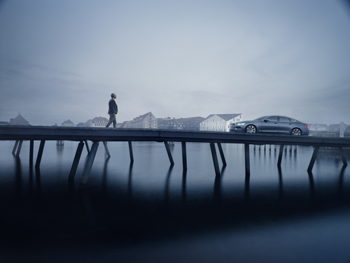
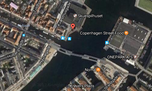
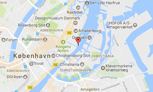
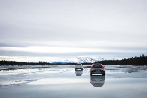
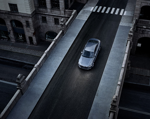
2016 Volvo S90 at the waterfront promenade on Nyhavn at Skuespilhuset (Royal Danish Playhouse) in Copenhagen with Krøyers Plads in the background.

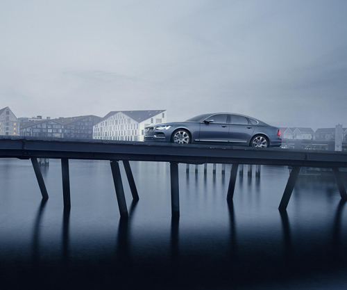
2016 – Volvo S90 at Skuespilhuset in Copenhagen

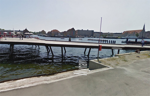
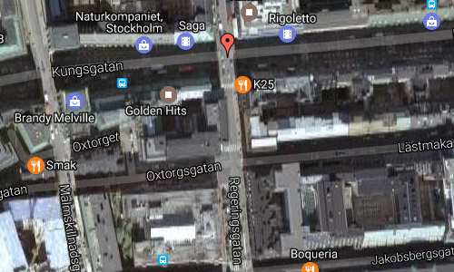
2017 – Waterfront promenade on Nyhavn at Skuespilhuset (Royal Danish Playhouse) in Copenhagen (Google Streetview)

The Royal Danish Playhouse (Danish: Skuespilhuset) is a theatre building for the Royal Danish Theatre, situated on the harbour front in the Frederiksstaden neighbourhood of central Copenhagen, Denmark. It was created as a purpose-built venue for dramatic theatre, supplementing the theatre’s old venue from 1874 on Kongens Nytorv and the 2004 Copenhagen Opera House, which are used for ballet and opera.

The Royal Playhouse is designed by the Danish architectural practice Lundgaard & Tranberg and received a RIBA European Award in 2008 for its architecture as well as a Red dot design award for the design of the chairs.

Since the 1880s Copenhagen city started the discussion of building a new Royal Playhouse for the latest trend in acting, where focus was on the more natural and intimate drama speaking works as opposed to the popular recital theater of the time.

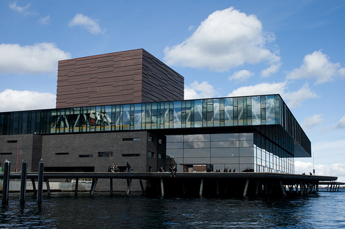
The theatre is designed by the Danish architectural practice Lundgaard & Tranberg. It is built in a long, slim, deep-brown brick that was specially developed for the project. The exterior is dominated by a continuous glass-encased top story with offices and back-stage facilities for the actors. Above the glass band is the dark copper-clad cube of the scene tower.

The glazed foyer facing the water runs along the entire length of the building . It affords panoramic views of the harbour and contains a restaurant and a cafë.

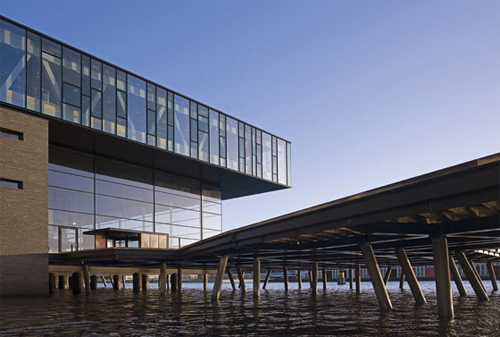
With about 40 per cent of the building projecting over the water, the waterfront promenade pivots around the playhouse, diverting pedestrians onto a raised 150 metre long walkway layered with rustic oak planks placed on Venetian-style crooked columns creating a floating feel.

More information at en.wikipedia.org, kglteater.dk, www.ltarkitekter.dk and www.dac.dk.

Volvo Photography Locations

Carrer del Comte de Salvatierra in Barcelona – ES 🇪🇸

February 16th, 2017

International Volvo Photo Locations Part 263
Click for Volvo Photography Locations Overview

2014 – Volvo XC60 on Carrer del Comte de Salvatierra in Barcelona, Spain 🇪🇸.

2014 - Volvo XC60

2014 – Volvo XC60 on Carrer del Comte de Salvatierra in Barcelona, Spain 🇪🇸.

2014 – Volvo XC60 on Carrer del Comte de Salvatierra in Barcelona, Spain 🇪🇸.

2017 – Carrer del Comte de Salvatierra in Barcelona (Google Streetview)

2015 – Carrer del Comte de Salvatierra in Barcelona (Google Streetview)

Carrer del Comte de Salvatierra is a street in Barcelona, Spain.

It is located in the Sarrià-Sant Gervasi distric, close to the Avinguda Diagonal. Sarrià-Sant Gervasi is one of the biggest districts of Barcelona, situated on the north-west of the city, surrounded by the districts of Les Corts, Gràcia, and Eixample i Horta-Guinardo and by the villages of Sant Just, Sant Feliu, Molins de Rei, and Sant Cugat. It is formed by the old villages of Sarrià (added to Barcelona in 1927), Vallvidrera (added to Sarrià in 1890), Santa Creu d’Olorda (added to Sarrià in 1916), and Sant Gervasi (“Saint Gervasius”) de Cassoles (added to Barcelona in 1897). The first written document found about Sarrià dates from the year 987, and the origins of the village are a Roman colony. The old Monestir de Pedralbes belonged to the village of Sarrià, and it is now the Museo Thyssen-Bornemisza.

At the end of this street you will find Carrer de Balmes, named after the Catalan philosopher and ecclesiastic Jaume Balmes and this is one of the most important avenues in Barcelona. It was devised in 1859 as part of Ildefons Cerdà urban plan.

Balmes is along Carrer Muntaner the longest road stretching from the sea towards the mountainside. It starts in the crossing of Pelai and Bergara streets and crosses the Eixample and Sant Gervasi districts, ending in Plaça John Fitzgerald Kennedy, by Avinguda del Tibidabo and Tramvia Blau. The Sant Gervasi part of the street was constructed after 1908.

Carrer de Balmes is also part of the so-called Gaixample, Barcelona’s gay village and hosts one of its most famous clubs, Arena.

Banc Sabadell is headquartered at the crossing of Carrer de Balmes with Avinguda Diagonal.

More information at www.barcelonaturisme.com.

Volvo Photography Locations

Andsjön near Undersåker and Åre 🇸🇪

February 14th, 2017

Volvo Photo Locations Part 269
Historic Volvo Photography Locations Overview
bookmark www.volvophotolocations.com today!

2013 – Volvo V40 Cross Country near Lake Andsjön in Åre, Jämtland, Sweden

2013 – Volvo V40 Cross Country near Lake Andsjön in Åre, Jämtland, Sweden

2013 – Volvo V40 Cross Country near Lake Andsjön in Åre Jämtland Sweden

2013 – Volvo V40 Cross Country

2017 – Andsjön in Undersåker (Panoramio – Stefan Helsing)

2017 – Andsjön in Undersåker

Andsjön is a lake in Åre kommun in Jämtland and is part of Indalsälvens main basin. The lake has an area of 0,956 square kilometers and is located 512.2 meters above sea level.

The lake is a popular place during winter time for ice drives. Volvo used to invited regularly journalist to this place to test drive cars.

2017 – Volvo V90 Cross Country on Andsjön lake

2017 – Volvo V90 Cross Country on Andsjön lake

2017 – Volvo XC90 and Volvo V40 Cross Country at Andsjön Sweden

In the winter of 2017, several journalists from all over the world visited this lake to test drive Volvos Cross Country line up: Volvo V90 Cross Country, Volvo XC90 and Volvo V40 Cross Country.

2017 – Volvo V90 Cross Country

2017 – Volvo V90 Cross Country

2017 – Volvo V90 Cross Country

2017 – Volvo V90 Cross Country

2017 – Volvo V90 Cross Country

Undersåker is a locality situated in Åre Municipality, Jämtland County, Sweden with 438 inhabitants in 2010. Edsåsdalen lies within the Undersåker locality approximately 8 kilometres from the railway station.

Åre Municipality (Swedish: Åre kommun) is a municipality in Jämtland County in northern Sweden. Its seat is located in Järpen.

The present municipality was formed in 1974 through the amalgamation of “old” Åre Municipality with the surrounding municipalities Hallen, Kall, Mörsil and Undersåker. The largest village, Järpen, situated in Undersåker, was chosen as the seat of the new entity.

Åre (Swedish pronunciation: [o:re]) is a locality and one of the leading Scandinavian ski resorts situated in Åre Municipality, Jämtland County, Sweden with 1,417 inhabitants in 2010. It is however, not the seat of the municipality, which is Järpen. 25% of the municipal industry is based on tourism, most notably the downhill skiing and biking resorts in Åre and Storlien. The growth in tourism has resulted in the development of hotels, recreational and shopping opportunities in the area.

Tourism in Åre started as King Oscar II in 1882 supervised construction of the railroad to Trondheim in Norway. With this new railroad many people came to Åre to breathe the fresh air and to walk to the top of Åreskutan. They were soon known as “air-guests” (luftgäster).

There was no hotel, but in 1888 Albin Wettergren opened a restaurant by the railroad station. In 1891 Åre Tourist Station opened and even more guests were attracted to the village.

A woman from Östersund saw this increasing tourism as a great opportunity to open a hotel and did so in 1895. It was called “Hotell Åreskutan”. Also Albin Wettergren opened a hotel (“Grand Hotell”). These were only a few of all the hotels that were going to be founded in Åre.

In 1910, the Åre Bergbana was built and was the third one in Sweden after the one in Skansen (1898) and the one in Kirunavaara (1907). This was a more convenient way for the air-guests to reach the top of Åreskutan.

In 2008 the hotel Copperhill Mountain Lodge opened on the top of the Förberget Mountain in Åre, Sweden. Designed by American architect Peter Bohlin it is the only mountain hotel in Scandinavia referred to as a Design Hotel

The airport is situated 99 kilometres eastward, outside Östersund’s core, on the Frösön islet. Åre Östersund Airport is an international airport and the ninth biggest in Sweden with roughly 390 000 passengers 2005. The airport is one of few Swedish airports with incoming foreign charter traffic.

The European route E14 runs through Åre from Trondheim via Östersund to Sundsvall, where it merges with the European route E45.

Åre has also railway communications. Norrtåg operates Mittbanan from Storlien via Östersund to Sundsvall. Östersund is connected to Stockholm, Gothenburg and Malmö through long distance X 2000 (high speed trains), InterCity and night train.

More information at sv.wikipedia.org, www.bild.de, en.wikipedia.org and www.visitare.com.

Volvo Photo Locations

Renströmska on Sanatoriegatan in Göteborg 🇸🇪

February 12th, 2017

Volvo Photo Locations Part 268
Historic Volvo Photography Locations Overview

1972 Volvo 145 Express Ambulance at Renströmska Villan, former Renströmska sjukhuset on Sanatoriegatan in Kålltorp in Göteborg, Sweden.

2017 – Renströmska Villan, former Renströmska sjukhuset on Sanatoriegatan in Kålltorp in Göteborg, Sweden.

2017 – Renströmska Villan, former Renströmska sjukhuset on Sanatoriegatan in Kålltorp in Göteborg, Sweden.

Renströmska sjukhuset or hospital (also known as Sanatorium at Kålltorp), is a former sanatorium in the city district Kålltorp in Göteborg.

Today, it is known under the name Renströmska Villan. High uo on Sanatoriegatan in Kålltorp is Renströmska villa located. It was built as a sanatorium 1911-1913, designed by Ernst Torulf. The construction was financed by Sven Renström Fund, which supported the “tidiness, soundness and health” in Göteborg. The old castle-like building has been converted to 57 apartments in 2008.

Kålltorp, is district of Göteborg, related district area Örgryte-Härlanda.

More information at sv.wikipedia.org, www.egnahemsbolaget.se, www.gajdarkitekter.se and delsjoomradet.se.

Volvo Photo Locations

Everts Sjöbod in Grebbestad 🇸🇪

February 12th, 2017

Volvo Photo Locations Part 267
Historic Volvo Photography Locations Overview

2016 - Volvo XC60 at Everts Sjöbod on Grönemadsvägen in Grebbestad Sweden

2016 – Volvo XC60 at Everts Sjöbod on Grönemadsvägen in Grebbestad Sweden (Stefan Isaksson)

2017 – Everts Sjöbod in Grebbestad (evertssjobod.se)

Everts Sjöbod is located on Grönemadsvägen 61 in Grebbestad, north of Göteborg.

They arrange nature experiences with the ocean in focus. On these experiences you have the opportunity to taste all what the ocean have to give. Oysters, crabs, lobsters and shrimps is only a few of the delicious things you can eat here. Enjoy this good food together with a trip in the beautiful archipelago of the Swedish west coast.

The owners are two brothers that grew up in Grebbestad and look forward to share what Bohuslän have to give.


Fisherman Lars Karlsson braves the waters of Grebbestad to catch lobster the traditional Swedish way (Volvo Cars commercial)

Grebbestad is a locality situated in Tanum Municipality, Västra Götaland County, Sweden. As of 2010, there were 1,401 inhabitants, though this number can increase by as much as ten-fold during the summer. The town is also the harbour where the majority of Norway lobster (in Swedish havskräfta) are landed, as well as oysters.

More information at evertssjobod.se.

Volvo Photo Locations

Ankarsmedja near Klippan in Göteborg 🇸🇪

February 12th, 2017

Volvo Photo Locations Part 266
Historic Volvo Photography Locations Overview

2012 – Volvo S80 2.0 T at Ankarsmedja near Klippan in Göteborg

2012 – Volvo S80 at Ankarsmedja near Klippan in Göteborg

2017 – Ankarsmedja near Klippan in Göteborg (Panoramio)

2017 – Ankarsmedja near Klippan in Göteborg (Google Streetview)

Ankarsmedjan is a building and part of the Klippans kulturreservat in the citypart of Majorna in Göteborg. In the smithy they manufactured anchor and chain to the Ostindiska kompaniets ships, which had its place just around the corner.

The building is believed to be from the 1770’s, but there is no exact date for the construction. According to an oral tradition it would have belonged tot the Älvsborg fästning, but this has not been proved. On a map from 1783 the Ankarsmedja is shown.

Operations in the anchor smithy has varied over the years. The building’s eastern part was conducted recently herring smokehouse and foundry. It was later to be the storehouse for various workshops. Göteborg city renovated the building in the early 1970’s, a brick floor was added, whitewashed walls and a staircase was built up to the loft, which was reduced in size. Architects for the renovation was Forser Bengt Christer Larsson.

Gallery Kusten moved in 1973 from Klippan to Ankarsmedja and stayed there for until 2000. The following year it was taken over by Sjömagasinet restaurant, which has its main location, also around the corner.

More information at sv.wikipedia.org and www.sjomagasinet.se.

Volvo Photo Locations

Basargatan near Kungstorget in Göteborg 🇸🇪

February 12th, 2017

Volvo Photo Locations Part 265
Historic Volvo Photography Locations Overview

1967 – Volvo 144 S Polis at Basargatan near Kungstorget in Göteborg, Sweden.

2017 – Basargatan at Kungstorget in Göteborg (Google Streetview)

1984 – Katzska huset on Basargatan (www.szmediabild.se)

Basargatan is a street in the district Inom Vallgraven i central Göteborg. It is about 350 meters long, and extends from the Lilla Korsgatan to Kungsportsplatsen. The street even number from 2 to 12 and odd number from 5 to 7.

1901 – Basargatan and Kungstorget in Göteborg

The name was established in 1852 after the bazaar building on the Kungstorget, which was built in 1850 and demolished in 1966. Possibly names Stora and Lilla Bazargatan have occurred (1857, 1864) in all or part of the route.

1940 – Basargatan and Katzhuset at Kungstorget in Göteborg

In 1985 the so-called Katzska house in the southwest corner of the Kungstorget was demolished. Then there was smoke again at the Katzska balcony. For those who were not around ther between the years 1940 and 1970, it is difficult to understand what significance it had. The balcony belonged earlier to the clothing firm Pettersson and Katz and had a very strategic position, facing out towards the square. It became noticed during the spring of 1943. The Second World War lasted, Norway was occupied and in Göteborg planned a soiree in support of Norway and the family Katz whom borrowed happily out their balcony for the event. The balcony became the place where all the major charity concerts took place. Whether it was Karl Gerhard performance in the 40’s, Lapp-Lisa in the 50’s, pop idol Tages in the 60’s or Sten-Åke Cederhök in the 70’s. The advantage with the location was so clear that it could fit many people in the square. Up to 45000 people crowding around the Saluhallen. What most people remember, that was intermittent, was that this year’s Lucia appeared on the balcony. The final Lucia festivity waved there in 1974. The same year the family Katz sold their business and Katzska balcony ceased as the city’s own charity scene. Yet, raised some angry voices when both bosses Katzska house and the house was demolished. It was after all one historic place had disappeared.

More information at sv.wikipedia.org and www.platsr.se

Volvo Photo Locations

Bridge of Regeringsgatan over Kungsgatan in Stockholm 🇸🇪

February 12th, 2017

Volvo Photo Locations Part 264
Historic Volvo Photography Locations Overview

2016 - Volvo S90 at Regeringsgatan (crossing Kungsgatan) in Stockholm

2016 – Volvo S90 at Regeringsgatan (crossing Kungsgatan) in Stockholm

2017 – Bridge of Regeringsgatan over Kungsgatan in Stockholm (Google Streetview)

The Bridge of Regeringsgatan (Swedish: Regeringsgatans bro) or more correctly Bridge of Regeringsgatan over Kungsgatan (Regeringsgatans viadukt över Kungsgatan) is a bridge in central Stockholm, Sweden, taking the street Regeringsgatan (“The Government Street”) over Kungsgatan (“The King’s Street”). It was inaugurated in 1910.

The bridge is a combined arch and beam bridge made of three reinforced concrete beams vaulted underneath and resting on two supports. Its vertical sides dressed in granite, the bridge is 11,1 metres wide with a 6,7 metres wide roadway. In contrast to the parallel bridge Malmskillnadsbron, the Bridge of Regeringsgatan is using three arches to cross Kungsgatan; the central span, 14,5 metres in length, passes over the roadway below; while the two spans on it sides, 5,5 metres in length, passes over the pavements of Kungsgatan. The unwieldy intermediate supports makes effective usage of the street width below impossible, and substituting the present construction have therefore been suggested.

In Swedish the word viadukt is used slightly different than viaduct in English, and can thus signify basically any bridge stretching over land, typically a street or a railway, and itself typically part of a railway or motorway, regardless of the number of spans. Thus, in Swedish the Bridge of Regeringsgatan is therefore officially called a viadukt but name is here translated using the English word “bridge” instead.

More information at sv.wikipedia.org.

Volvo Photo Locations

Bjurslätts Torg on Karl Staaffsgatan in Göteborg 🇸🇪

February 11th, 2017

Volvo Photo Locations Part 263
Historic Volvo Photography Locations Overview

1953 – Volvo PV445 Duett at Bjurslätts Torg on Karl Staaffsgatan in Göteborg, Sweden 🇸🇪.

1953 - Volvo PV445 at Bjurslätts Torg in Göteborg

1953 – Volvo PV445 Duett at Bjurslätts Torg on Karl Staaffsgatan in Göteborg

1953 – Volvo PV445 at Bjurslätts Torg in Göteborg (Ratten)

1953 – Volvo PV445 at Bjurslätts Torg in Göteborg (Photo from the Volvo magazine Ratten)

1953 – Volvo PV445 Duett at Bjurslätts Torg on Karl Staaffsgatan in Göteborg, Sweden 🇸🇪.

2017 – Bjurslätts Torg on Karl Staaffsgatan in Göteborg (Flickr)

2017 – Bjurslätts Torg on Karl Staaffsgatan in Göteborg (Google Streetview)

1950 – Bjurslätts Torg on Karl Staaffsgatan in Göteborg

2017 – Bjurslätts Torg on Karl Staaffsgatan in Göteborg (Hitta.se)

Bjurslätts Torg is a place in Tolered in the Lundby area on Hisingen in Göteborg.

In 1949 a town plan for the area around Bjurslätt torg was made by Tage William-Olsson and it was built during the years 1950-1952. Architects of the center facility was Nils Einar Eriksson and Erik Ragndal. It consists of three angle-built three-story longhouses and a tower block on nine floors. The frukt (fruits) store on the photo was located in one of these towers.

Tage William-Olsson (8 June 1888 – 22 August 1960) was a Swedish architect and chief town planning architect of Göteborg. William-Olsson was born in London and was the creator of the important infrastructure-project, the traffic-roundabout Slussen in Stockholm.

Nils Einar Eriksson (19 juli 1899 (Stockholm)- 1978 (Göteborg), was a Swedish functionalist architect (funkisarkitekt) and has also been responsible for the Göteborgs konserthus.

Karl Albert Staaff (21 January 1860 – 4 October 1915) was a Swedish liberal politician and lawyer. He was chairman of the Liberal Coalition Party (1907–1915) and served twice as Prime Minister of Sweden (1905–1906 and 1911–1914). The contemporary Swedish Liberal party The Liberals counts him as the first among the more prominent leaders of Swedish 20th century liberalism, followed by such parliamentarians as Nils Edén, Carl Ekman, Nobel Prize laureate Bertil Ohlin, Gunnar Helén, Per Ahlmark and Bengt Westerberg.

More information at en.wikipedia.org.

Volvo Photo Locations

BBL HQ on Avenue Marnix in Brussels – B 🇧🇪

January 21st, 2017

International Volvo Photo Locations Part 262
Click for Volvo Photography Locations Overview

1970 – Volvo 144 Grand Luxe at Bank Brussels Lambert (BBL) headquarters (today ING Bank) at 24 Avenue Marnix in Brussels, Belgium 🇧🇪.

1970 - Volvo 144 Grand Luxe

1970 – Volvo 144 Grand Luxe at Bank Brussels Lambert (BBL) headquarters (today ING Bank) at 24 Avenue Marnix in Brussels, Belgium 🇧🇪. (thanks to Per Pettersson)

2017 – ING Bank HQ at 24 Avenue Marnix in Brussels Belgium (Google Streetview)

2017 – ING Bank HQ at 24 Avenue Marnix in Brussels Belgium (Google Streetview)

The headquarters of BBL (now an office of ING Group) was the Bank Lambert-building on Marnixlaan 24, Brussels. This modernist building was the only European building designed by the American architect Gordon Bunshaft making it one of the most important modernist architectural buildings in Belgium.

Gordon Bunshaft, (May 9, 1909 – August 6, 1990), was an American architect, a leading proponent of modern design in the mid-twentieth century. The long list of his notable buildings includes Lever House in New York, the Beinecke Rare Book and Manuscript Library at Yale University, the Hirshhorn Museum and Sculpture Garden in Washington, D.C., the National Commercial Bank in Jeddah, Saudi Arabia, 140 Broadway (Marine Midland Grace Trust Co.) and Manufacturers Hanover Trust Branch Bank in New York; the last was the first post-war “transparent” bank on the East Coast.

Bank Brussels Lambert or in french Banque Bruxelles Lambert was a Belgian bank that was created through merger in 1975 and became part of ING Group in 1998. It provided retail and commercial banking services to individuals and businesses in Belgium, together with related financial products such as insurance and asset management.

It was formed by the merger of two existing Belgium banks Banque de Bruxelles and Banque Lambert in 1975 making it at that time the second largest Belgian bank. It was sold to ING Group in 1998 who renamed the subsidiary ING Belgium.

Banque de Bruxelles was founded in 1871 and grew steadily over the ensuing six decades, acquiring interests in other banks in Belgium’s major cities. In 1931, these interests were combined in a single business which operated in traditional banking and in the management of industrial concerns based mainly in Belgium and Africa. Following the reform of the Belgian banking sector in 1934–35, the commercial banking activities were transferred to a new company formed on 30 January 1935 under the same registered name. As required by the reform, this transfer separated the banking and holding company functions.

Banque Lambert had its origins in the banking house founded by the Lambert family, financiers in Belgium since the country’s independence in 1830. After 1945, Banque Lambert rapidly developed its services and network, notably through the merger of a number of privately owned banks.

In 2017, Paul Malfroot from Jakobs Volvo Magazine visited the location with a restored Volvo 144 GL.

More information at www.architectura.be, en.wikipedia.org, en.wikipedia.org/wiki/Gordon_Bunshaft, www.fundinguniverse.com and about.ing.be.

Thanks to Per Pettersson for finding this Volvo Photo Location!

Volvo Photography Locations